

BURNT SWAMP ASSOCIATION

Baptist churches serving Lumbee and other tribes. Association was formed in 1881 at Burnt Swamp Church, then 2 1/2 mi. N.Plaque via North Carolina Highway Historical Marker Program, and is...
- ncmarkers
- north carolina
JOHN ENGLAND 1786-1842

Bishop of Charleston. He organized Roman Catholics in N.C. at Fayetteville Convention, & consecrated St. Patrick Church, 1829. Present church 4/10 mi. E.Plaque via North Carolina Highway...
- ncmarkers
- north carolina
WHITE LAKE CCC CAMP

An installation of the Civilian Conservation Corps. Initiated modern park improvements. Est. here 1935; closed 1942.Plaque via North Carolina Highway Historical Marker Program, and is used with...
- ncmarkers
- north carolina
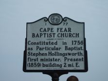
CAPE FEAR BAPTIST CHURCH

Constituted in 1756 as Particular Baptist. Stephen Hollingsworth, first minister. Present (1859) building 2 mi. E.Plaque via North Carolina Highway Historical Marker Program, and is used with...
- ncmarkers
- north carolina
CAPE FEAR BAPTIST CHURCH
Constituted in 1756 as Particular Baptist. Stephen Hollingsworth, first minister. Present (1859) building 2 mi. E.Plaque via North Carolina Highway Historical Marker Program, and is used with...
- ncmarkers
- north carolina
FUTURE FARMERS OF AMERICA

Began in N.C. as Young Tar Heel Farmers, 1928, to promote vocational agriculture in schools. Camp here since 1928.Plaque via North Carolina Highway Historical Marker Program, and is used with...
- ncmarkers
- north carolina
FEDERAL HOSPITAL

The 1865 home of Wm. Smith, 100 yds. E., was used as a hospital for Union troops in the Battle of Averasboro, March 15-16, 1865.Plaque via North Carolina Highway Historical Marker Program, and...
- ncmarkers
- north carolina
FEDERAL ARTILLERY

From a point 50 yards west three batteries of artillery under Major J. A. Reynolds shelled the Confederate first line of earthworks.Plaque via North Carolina Highway Historical Marker Program, and...
- ncmarkers
- north carolina
'OAK GROVE'

Plantation home of John Smith, used as a Confederate hospital during the Battle of Averasboro, March 16, 1865.Plaque via North Carolina Highway Historical Marker Program, and is used with their...
- ncmarkers
- north carolina
CONFEDERATE FIRST LINE
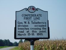
Gen. W. B. Taliaferro's division occupied trenches crossing the road at this point, March 15-16, 1865.Plaque via North Carolina Highway Historical Marker Program, and is used with their...
- ncmarkers
- north carolina
RHETT'S BRIGADE
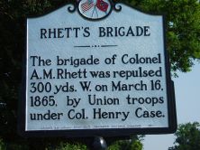
The brigade of Colonel A. M. Rhett was repulsed 300 yds. W. on March 16, 1865, by Union troops under Col. Henry Case.Plaque via North Carolina Highway Historical Marker Program, and is used with...
- ncmarkers
- north carolina
CHARTER OF THE UNIVERSITY OF N.C.
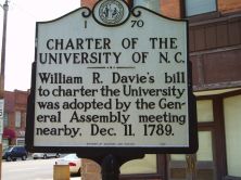
William R. Davie's bill to charter the University was adopted by the General Assembly meeting nearby, Dec. 11, 1789.Plaque via North Carolina Highway Historical Marker Program, and is used with...
- ncmarkers
- north carolina
JOHN OWEN 1787-1841

Governor, 1828-1830; state legislator; and Whig party leader. His home stood 4 miles NW.Plaque via North Carolina Highway Historical Marker Program, and is used with their permission. Full page...
- ncmarkers
- north carolina
STEAMBOAT TRADE

Naval stores and lumber were primary cargo on vessels navigating Black River, ca. 1875-1914. Remains of the steamer A.J. Johnson 60 yds. S.Plaque via North Carolina Highway Historical Marker...
- ncmarkers
- north carolina
CROATAN NORMAL SCHOOL
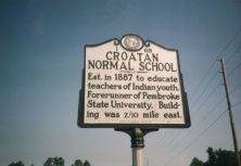
Est. in 1887 to educate teachers of Indian youth. It was the forerunner of UNC-Pembroke. Building was 2/10 mile east.Plaque via North Carolina Highway Historical Marker Program, and is used with...
- ncmarkers
- north carolina
FIRST RURAL HEALTH DEPARTMENT

In 1912 Robeson County established first rural health department in U.S. three blocks N.Plaque via North Carolina Highway Historical Marker Program, and is used with their permission. Full page...
- ncmarkers
- north carolina
THE BARTRAMS

Naturalists John and William Bartram, in 1765 and later, used their kinsman's house, Ashwood, as operating base. Stood 2 mi. E.Plaque via North Carolina Highway Historical Marker Program, and...
- ncmarkers
- north carolina
WARREN WINSLOW 1810-1862
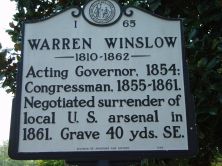
Acting Governor, 1854; Congressman, 1855-1861. Negotiated surrender of local U.S. arsenal in 1861. Grave 40 yds. SE.Plaque via North Carolina Highway Historical Marker Program, and is used with...
- ncmarkers
- north carolina
CONFEDERATE WOMEN'S HOME

Built in 1915 for the widows and daughters of state's Confederate veterans. Closed, 1981. Cemetery 300 yds. W.Plaque via North Carolina Highway Historical Marker Program, and is used with their...
- ncmarkers
- north carolina
C. M. STEDMAN 1841-1930

Last Confederate officer in Congress, 1911-1930; lawyer & lt.-governor. Grave is 2 blks. east.Plaque via North Carolina Highway Historical Marker Program, and is used with their permission. Full...
- ncmarkers
- north carolina