

ALEX MANLY 1866-1944

Edited black-owned Daily Record four blocks east. Mob burned his office, Nov. 10, 1898, leading to "race riot" & restrictions on black voting in N.C.Plaque via North Carolina Highway...
- ncmarkers
- north carolina
W. H. C. WHITING 1824-1865

Confederate major general and engineer. He devised the Cape Fear defense system. Wounded nearby in fall of fort. Died in Union hospital.Plaque via North Carolina Highway Historical Marker...
- ncmarkers
- north carolina
FALL OF WILMINGTON

Union assault on Hoke's entrenched Confederates led to the city's fall, February 22, 1865. Earthworks were nearby.Plaque via North Carolina Highway Historical Marker Program, and is used with...
- ncmarkers
- north carolina
TOPSAIL BATTERY
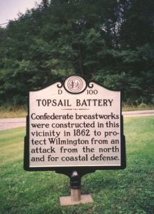
Confederate breastworks were constructed in this vicinity in 1862 to protect Wilmington from an attack from the north and for coastal defense.Plaque via North Carolina Highway Historical Marker...
- ncmarkers
- north carolina
CORNELIUS HARNETT 1723-1781

Revolutionary statesman. Prominent in resistance to British rule and the creation of independent N.C. Home was 1/4 mi. N.Plaque via North Carolina Highway Historical Marker Program, and is...
- ncmarkers
- north carolina
FORT MACON

Built by U.S. Corps of Engineers, 1826-34. Good example of brick fort. Seized by Confederates, April 14, 1861. Scene of battle, April 25, 1862.Plaque via North Carolina Highway Historical Marker...
- ncmarkers
- north carolina
SIEGE OF FORT MACON
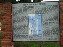
Plaque via North Carolina Highway Historical Marker Program, and is used with their permission. Full page here (NC Marker ID CC3)
- ncmarkers
- north carolina
FORT MACON

Built 1826-34 to protect Beaufort Inlet. Replaced Fort Hampton. State park. 5 1/2 miles southeast.Plaque via North Carolina Highway Historical Marker Program, and is used with their permission....
- ncmarkers
- north carolina
JACOB HENRY ca. 1775-1847

First Jewish member of N.C. legislature, 1808. Delivered a landmark address on religious freedom. Lived here.Plaque via North Carolina Highway Historical Marker Program, and is used with...
- ncmarkers
- north carolina
KING SOLOMON LODGE

First African American Masonic lodge in N.C.; est. 1865. Erected in 1870, the building was moved here in 1920s.Plaque via North Carolina Highway Historical Marker Program, and is used with...
- ncmarkers
- north carolina
ANDREW'S CHAPEL

Est. 1802 to serve all local Methodists. After 1864 mother church for the A.M.E. Zion faith, it became St. Peter’s, 1879. Stood 1/10 mi. S.Plaque via North Carolina Highway Historical...
- ncmarkers
- north carolina
SPANISH ATTACK
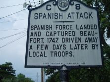
Spanish force landed and captured Beaufort, 1747. Driven away a few days later by local troops.Plaque via North Carolina Highway Historical Marker Program, and is used with their permission. Full...
- ncmarkers
- north carolina
WOMEN MARINES
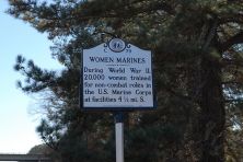
During World War II, 20,000 women trained for non- combat roles in the U.S. Marine Corps at facilities 4 1/2 mi. S.Plaque via North Carolina Highway Historical Marker Program, and is used with...
- ncmarkers
- north carolina
CAROLINA CITY

Union occupied the town March 22, 1862, & used this area in staging the Fort Macon campaign. Union camps remained in vicinity until 1865.Plaque via North Carolina Highway Historical...
- ncmarkers
- north carolina
GRAHAM A. BARDEN 1896-1967
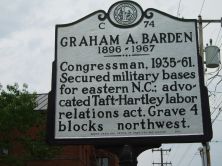
Congressman, 1935-61. Secured military bases for eastern N.C.; advocated Taft-Hartley labor relations act. Grave 4 blocks northwest.Plaque via North Carolina Highway Historical Marker Program, and...
- ncmarkers
- north carolina
MONTFORD POINT

Recruit training depot for black Marines, 1942-1949. In 1974 renamed Camp Johnson for Sgt. Gilbert Johnson, drill instructor. One mi. SE.Plaque via North Carolina Highway Historical Marker...
- ncmarkers
- north carolina
CYRUS THOMPSON 1855-1930

Physician and orator. Secretary of State of N.C., 1897-1901. Farmers' Alliance and Populist leader. Grave 4 mi. W.Plaque via North Carolina Highway Historical Marker Program, and is used with...
- ncmarkers
- north carolina
CAMP LEJEUNE

Established 1 May 1941 by the U.S. Marine Corps for amphibious training. Named for Lt. Gen. John A. Lejeune, USMC, 13th Commandant, 1920-1929.Plaque via North Carolina Highway Historical Marker...
- ncmarkers
- north carolina
BAYARD WOOTTEN 1875-1959

Pioneer photographer of N.C. and the South. An advocate of equal rights for women. Began career ca. 1904 in this house where she was born.Plaque via North Carolina Highway Historical...
- ncmarkers
- north carolina
RICHARD DOBBS SPAIGHT
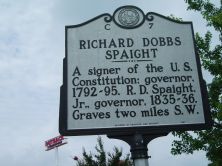
A signer of the U.S. Constitution; governor, 1792-95. R. D. Spaight, Jr., governor, 1835-36. Graves two miles S.W.Plaque via North Carolina Highway Historical Marker Program, and is used with...
- ncmarkers
- north carolina