
ASHPOLE CHURCH
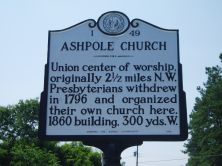
Union center of worship, originally 2 1/2 miles N.W. Presbyterians withdrew in 1796 and organized their own church here. 1860 building, 300 yds. W.Plaque via North Carolina Highway...
- ncmarkers
- north carolina
TEMPERANCE HALL

Meeting hall of the Richmond Temperance and Literary Society, 1860 to 1890's. Sacked by Sherman's army in 1865. Stands 1 1/2 mi. W.Plaque via North Carolina Highway Historical Marker Program, and...
- ncmarkers
- north carolina
CHAS. W. CHESNUTT 1858-1932

Negro novelist and short story writer, teacher and lawyer. Taught in a school which stood here.Plaque via North Carolina Highway Historical Marker Program, and is used with their permission....
- ncmarkers
- north carolina
STATE SANATORIUM

Opened in 1908. First state institution in North Carolina for treating tuberculosis. Sponsored by Dr. J. E. Brooks of Greensboro.Plaque via North Carolina Highway Historical Marker Program, and...
- ncmarkers
- north carolina
SHERMAN'S MARCH

General Sherman, with a part of his army, on March 9-10, 1865, camped here at Bethel Presbyterian Church (organized before 1800).Plaque via North Carolina Highway Historical Marker Program, and...
- ncmarkers
- north carolina
JAMES LYTCH

Invented Lytch cotton planter (patented 1878), a favorite in the South, and other implements. Shops were 1/4 mile S.W. This was his home.Plaque via North Carolina Highway Historical Marker...
- ncmarkers
- north carolina
GUN FACTORY

Revolutionary War arms factory operated in this vicinity by Richard Herring and John Devane until destroyed by the Tories.Plaque via North Carolina Highway Historical Marker Program, and is...
- ncmarkers
- north carolina
RICHARD CLINTON

Lieut. colonel militia, member Provincial Congress, 1775, legislature, conventions 1788, 1789. This town named for him. Home was nearby.Plaque via North Carolina Highway Historical Marker Program,...
- ncmarkers
- north carolina
BABE RUTH

Hit his first home run in professional baseball, March, 1914. 135 yds. N.W. In this town George Herman Ruth acquired the nickname "Babe."Plaque via North Carolina Highway Historical...
- ncmarkers
- north carolina
MARION BUTLER

United States Senator, 1896-1901. Populist- Republican. Supporter of education, sponsor of rural free delivery act. Birthplace is here.Plaque via North Carolina Highway Historical Marker Program,...
- ncmarkers
- north carolina
CAMP MACKALL

Primary training site for U.S. Army airborne troops in World War II. Established 1943; named for Private John Thomas Mackall. Two miles W.Plaque via North Carolina Highway Historical Marker...
- ncmarkers
- north carolina
THOMAS ROBESON

Colonel in Revolution, member of provincial congresses and state senator. Robeson County is named for him. His home stood 1/2 mile N.E.Plaque via North Carolina Highway Historical Marker Program,...
- ncmarkers
- north carolina
MONROE'S CROSSROADS

Gen. Kilpatrick's Union cavalry repulsed Gen. Hampton's Confederate cavalry there, March 10, 1865, ten miles north. Now in Fort Bragg area.Plaque via North Carolina Highway Historical Marker...
- ncmarkers
- north carolina
JOHN WILLIS

Founder of Lumberton, captain in Revolution, later brigadier general; member of legislature, conventions of 1788, '89. Plantation was here.Plaque via North Carolina Highway Historical Marker...
- ncmarkers
- north carolina
ANGUS W. McLEAN
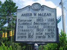
Governor, 1925-1929, Assistant Secretary of the United States Treasury, 1920-1921. Home is 1 mile south, grave 100 yards N.W.Plaque via North Carolina Highway Historical Marker Program, and...
- ncmarkers
- north carolina
MOORE'S CAMP

Prior to the Battle of Moores Creek Bridge, forces of Gen. James Moore, Whig commander, camped, Feb. 15-21, 1776, 1 1/2 miles northeast.Plaque via North Carolina Highway Historical Marker...
- ncmarkers
- north carolina
JAMES C. DOBBIN

Secretary of United States Navy, 1853-57. Helped found State Hospital for Insane. Home one block north.Plaque via North Carolina Highway Historical Marker Program, and is used with their...
- ncmarkers
- north carolina
EDENBOROUGH MEDICAL COLLEGE

Early medical school, chartered 1867, conducted by Dr. Hector McLean. Closed c. 1877. Stood one-half mile south.Plaque via North Carolina Highway Historical Marker Program, and is used with...
- ncmarkers
- north carolina
THOMAS O. MOORE 1804-1876

Governor of Louisiana, 1860-1864; a leader of the secession movement. His birthplace stood 4 1/2 miles northwest.Plaque via North Carolina Highway Historical Marker Program, and is used with...
- ncmarkers
- north carolina
FAYETTEVILLE STATE UNIVERSITY

Est. 1867 as Howard School. State-supported since 1877. A part of The University of North Carolina since 1972.Plaque via North Carolina Highway Historical Marker Program, and is used with...
- ncmarkers
- north carolina