
LILLIAN EXUM CLEMENT STAFFORD 1886-1925
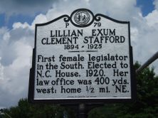
First female legislator in the South. Elected to N.C. House, 1920. Her law office was 400 yds. west; home 1/2 mi. NE.Plaque via North Carolina Highway Historical Marker Program, and is used with...
- ncmarkers
- north carolina
STONEMAN'S RAID

On a raid through western North Carolina Gen. Stoneman's U.S. Cavalry passed through Hendersonville, Apr. 23, 1865.Plaque via North Carolina Highway Historical Marker Program, and is used with...
- ncmarkers
- north carolina
BASCOM LAMAR LUNSFORD
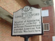
"Minstrel of Appalachia." Folklorist, collector, & performer. Pioneered and promoted American folk festivals. Was born here.Plaque via North Carolina Highway Historical Marker Program, and is...
- ncmarkers
- north carolina
ARNOLD GUYOT 1807-1884

Geographer who measured elevations at sites in western N.C., 1856-1860, including Hominy Creek Gap near here & Mt. Guyot, 25 mi. N.W.Plaque via North Carolina Highway Historical Marker...
- ncmarkers
- north carolina
PLOTT HOUND
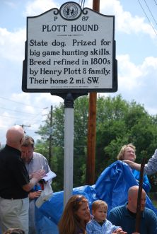
State dog. Prized for big game hunting skills. Breed refined in 1800s by Henry Plott & family. Their home 2 mi. SW.Plaque via North Carolina Highway Historical Marker Program, and is used with...
- ncmarkers
- north carolina
INMAN CHAPEL

Founded 1868. Oldest Universalist church in western N.C. Hannah J. Powell led mission work and school, 1921-42, at site 100 yards south.Plaque via North Carolina Highway Historical Marker Program,...
- ncmarkers
- north carolina
BATTLE OF ASHEVILLE
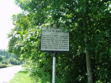
On April 3, 1865, Union Col. Isaac M. Kirby left East Tenn. with 1100 men on a raid against Asheville. On April 6, Kirby's force was defeated by local militia under Col. G. W. Clayton. Earthworks...
- ncmarkers
- north carolina
STONEMAN'S RAID

On a raid through western North Carolina Gen. Stoneman's U.S. Cavalry occupied Asheville on April 26, 1865.Plaque via North Carolina Highway Historical Marker Program, and is used with...
- ncmarkers
- north carolina
WADE HAMPTON

Confederate General, Governor of S.C., 1876-79, U.S. Senator. His summer home, "High Hampton," stood 1 1/3 miles southeast.Plaque via North Carolina Highway Historical Marker Program, and is used...
- ncmarkers
- north carolina
CHEROKEE WAR
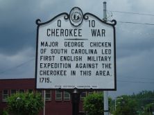
Major George Chicken of South Carolina led first English military expedition against the Cherokee in this area, 1715.Plaque via North Carolina Highway Historical Marker Program, and is used with...
- ncmarkers
- north carolina
FORT BUTLER
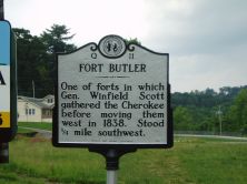
One of forts in which Gen. Winfield Scott gathered the Cherokee before moving them west in 1838. Stood 1/4 mile southwest.Plaque via North Carolina Highway Historical Marker Program, and is...
- ncmarkers
- north carolina
YONAGUSKA ca. 1760-1839

Chief of Oconaluftee Cherokee. He advocated temperance and opposed removal of his people from their homeland. Lived in this vicinity.Plaque via North Carolina Highway Historical Marker...
- ncmarkers
- north carolina
CHEROKEE INDIAN RESERVATION

Established by United States for the Eastern Band of Cherokee after the removal of 1838. (Reverse) (LEAVING) CHEROKEE RESERVATION / Established by United States for the Eastern Band of...
- ncmarkers
- north carolina
CHEROKEE INDIAN RESERVATION

Established by United States for Eastern Band of Cherokee Indians after removal of 1838. (Reverse) (LEAVING) Established by United States for Eastern Band of Cherokee Indians after removal...
- ncmarkers
- north carolina
FORT HEMBREE

One of the forts where General Winfield Scott's United States forces gathered the Cherokee before moving them west, stood 3/4 mi. N.W.Plaque via North Carolina Highway Historical Marker...
- ncmarkers
- north carolina
ELLEN BLACK WINSTON 1903-1984

Social worker. Led N.C. Board of Public Welfare, 1944-63; first Commissioner of U.S. Welfare. Her grave is 1/10 mi. W.Plaque via North Carolina Highway Historical Marker Program, and is used with...
- ncmarkers
- north carolina
JUNALUSKA ca. 1779-1858

Cherokee warrior, fought for U.S. in Creek War, 1814. Granted citizenship and land by N.C., 1847. Grave is one mile S.W.Plaque via North Carolina Highway Historical Marker Program, and is...
- ncmarkers
- north carolina
NORTH CAROLINA- GEORGIA

NORTH CAROLINA / Colonized, 1585-87, by first English settlers in America; permanently settled c. 1650; first to vote readiness for independence, Apr. 12, 1776 b/w GEORGIA / The colony of...
- ncmarkers
- north carolina
TSALI

Cherokee who resisted removal & escaped from U.S. troops; executed nearby, 1838. Story inspired Unto These Hills.Plaque via North Carolina Highway Historical Marker Program, and is used with...
- ncmarkers
- north carolina
INDIAN BOUNDARY

Near here the highway crosses Meigs-Freeman Line, surveyed in 1802, boundary between whites & Cherokees until 1819.Plaque via North Carolina Highway Historical Marker Program, and is used with...
- ncmarkers
- north carolina