
WILLIAM MOORE

Captain of militia force which marched against the Cherokee in Nov., 1776. A fort which he built stood near here. His home was 200 yds. E.Plaque via North Carolina Highway Historical...
- ncmarkers
- north carolina
STONEMAN'S RAID

Southern troops turned back Stoneman's U.S. cavalry, raiding through western North Carolina, at Swannanoa Gap, near here, April 20, 1865.Plaque via North Carolina Highway Historical...
- ncmarkers
- north carolina
UNIVERSITY OF N.C. AT ASHEVILLE

Established 1927; became Asheville-Biltmore College 1936. Moved here in 1961. A campus of The University of North Carolina, 1969.Plaque via North Carolina Highway Historical Marker Program, and is...
- ncmarkers
- north carolina
CONFEDERATE ARMORY

Manufactured Enfield-type rifles. In 1863 plant moved to Columbia, S.C. Building was located 1/4 mi. SE. Burned in 1865.Plaque via North Carolina Highway Historical Marker Program, and is...
- ncmarkers
- north carolina
N.C. EDUCATION ASSOCIATION

Organized in 1884 as N.C. Teachers Assembly in the White Sulphur Springs Hotel. Building was one mile northwest.Plaque via North Carolina Highway Historical Marker Program, and is used with...
- ncmarkers
- north carolina
FORESTRY SCHOOL
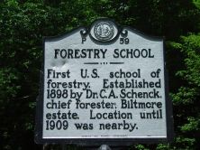
First U.S. school of forestry. Established 1898 by Dr. C. A. Schenck, chief forester, Biltmore estate. Location until 1909 was nearby.Plaque via North Carolina Highway Historical Marker...
- ncmarkers
- north carolina
EDGAR W. ('BILL') NYE 1850-1896

Humorist and journalist. Retired to N.C., 1891. Lived at "Buck Shoals," 3 1/2 mi. W. His grave is one mile north.Plaque via North Carolina Highway Historical Marker Program, and is used with...
- ncmarkers
- north carolina
SHERRILL'S INN

Established in 1834 to serve travelers crossing Hickory Nut Gap. In continuous service until 1909. House stands 300 yards south.Plaque via North Carolina Highway Historical Marker Program, and...
- ncmarkers
- north carolina
WEAVER COLLEGE
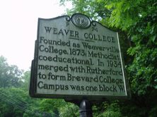
Founded as Weaverville College, 1873; Methodist, coeducational. In 1934 merged with Rutherford to form Brevard College. Campus was one block W.Plaque via North Carolina Highway Historical Marker...
- ncmarkers
- north carolina
ASHEVILLE NORMAL SCHOOL

Presbyterian. Opened 1887 as Home Industrial School. Teacher's College 1892-1944. Stood nearby.Plaque via North Carolina Highway Historical Marker Program, and is used with their permission. Full...
- ncmarkers
- north carolina
SHAWS CREEK CHURCH AND CAMP GROUNDS

Methodist. Congregation was organized at a camp meeting ca. 1810, on land donated by James Johnson. Church, 1905, is .3 mi. N.Plaque via North Carolina Highway Historical Marker Program, and is...
- ncmarkers
- north carolina
BLACK MOUNTAIN COLLEGE

Est. in 1933; closed 1956. Experimental school with emphasis on fine arts & progressive education. Campus was 3 mi. NW.Plaque via North Carolina Highway Historical Marker Program, and is used with...
- ncmarkers
- north carolina
WOLFE'S ANGEL
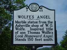
Marble statue from the Asheville shop of W. O. Wolfe. Inspired title of son Thomas Wolfe's Look Homeward Angel. Stands 150 feet south.Plaque via North Carolina Highway Historical Marker...
- ncmarkers
- north carolina
BALLADRY

English folklorist Cecil Sharp in 1916 collected ballads in the "Laurel Country." Jane Gentry, who supplied many of the songs, lived here.Plaque via North Carolina Highway Historical Marker...
- ncmarkers
- north carolina
CIVILIAN CONSERVATION CORPS

CCC camps were established as a New Deal relief measure. Camp John Rock, among first, operated here, 1933-36.Plaque via North Carolina Highway Historical Marker Program, and is used with...
- ncmarkers
- north carolina
BILTMORE HOUSE

Designed for George W. Vanderbilt by Richard M. Hunt. Constructed, 1890-1895. Opened to public, 1930. Three miles west.Plaque via North Carolina Highway Historical Marker Program, and is used with...
- ncmarkers
- north carolina
WARREN WILSON COLLEGE
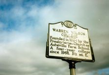
Founded in 1894 by the Presbyterian Church as Asheville Farm School. A four-year college since 1966. 1 1/2 mi. E.Plaque via North Carolina Highway Historical Marker Program, and is used with their...
- ncmarkers
- north carolina
QUALLA BOUNDARY

Soco Gap, initial point of U.S. survey, 1876, of Cherokee Reservation, created through earlier efforts of W. H. Thomas, white Cherokee chief.Plaque via North Carolina Highway Historical Marker...
- ncmarkers
- north carolina
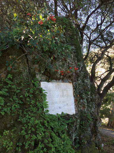
BREVARD COLLEGE
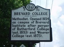
Methodist. Opened 1934 on campus of Brevard Institute after merger of Rutherford College (est. 1853) and Weaver College (est. 1873).Plaque via North Carolina Highway Historical Marker Program, and...
- ncmarkers
- north carolina
SHELTON LAUREL MASSACRE

Thirteen men and boys, suspected of Unionism, were killed by Confederate soldiers in early 1863. Graves 8 mi. E.Plaque via North Carolina Highway Historical Marker Program, and is used with...
- ncmarkers
- north carolina