
PLEASANT GARDENS

Home of Joseph McDowell (1758-1795), soldier and physician. Officer at the Battle of Kings Mountain.Plaque via North Carolina Highway Historical Marker Program, and is used with their permission....
- ncmarkers
- north carolina
BROUGHTON HOSPITAL

State hospital for care of mentally ill; opened 1883. Named in 1959 for J. Melville Broughton, governor, 1941-1945.Plaque via North Carolina Highway Historical Marker Program, and is used with...
- ncmarkers
- north carolina
ELISHA MITCHELL 1793-1857

Scientist and professor. Died in attempt to prove this mountain highest in eastern U.S. Grave is at the summit, 285 yds. S.Plaque via North Carolina Highway Historical Marker Program, and is...
- ncmarkers
- north carolina
ANDREWS GEYSER

Built ca. 1885 to mark railroad gateway to the Blue Ridge Mts. Restored in 1911 & 1975. Named for A. B. Andrews of Raleigh. Located 2.1 miles north.Plaque via North Carolina Highway...
- ncmarkers
- north carolina
SHEPHERD M. DUGGER

Author of The Balsam Groves of the Grandfather Mountain, 1892; educator and humorist. Grave one block South.Plaque via North Carolina Highway Historical Marker Program, and is used with...
- ncmarkers
- north carolina
CARSON HOUSE
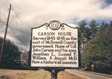
Served 1843-1845 as the seat of McDowell County government. Home of Col. John Carson and his sons, Jonathan L., Samuel P., William, & Joseph McD. Now a historical museum.Plaque via North...
- ncmarkers
- north carolina
BURKE COURTHOUSE

Built of local cut stone, ca. 1835, by James Binnie. August terms of State Supreme Court held here, 1847-61. Raided by Union force 1865. Remodeled 1901.Plaque via North Carolina Highway Historical...
- ncmarkers
- north carolina
STONEMAN'S RAID

On raid through western North Carolina Federal forces under Gen. George Stoneman erected a palisaded fort here in April 1865.Plaque via North Carolina Highway Historical Marker Program, and...
- ncmarkers
- north carolina
SWANNANOA GAP

Used by Indians and pioneers in crossing Blue Ridge. General Rutherford's expedition against Cherokee passed here, September, 1776.Plaque via North Carolina Highway Historical Marker Program, and...
- ncmarkers
- north carolina
FRONTIER FORT

Early outpost against Indians. Used by Gen. Rutherford in expedition against Cherokee, Sept., 1776. Stood nearby and gave name to this town.Plaque via North Carolina Highway Historical Marker...
- ncmarkers
- north carolina
DAVENPORT COLLEGE

For women; chartered 1859 by Methodist Episcopal Church, South; merged with Greensboro College, 1933. Two bldgs. stand 100 ft. S.W.Plaque via North Carolina Highway Historical Marker Program, and...
- ncmarkers
- north carolina
QUAKER MEADOWS

Rendezvous for "Over-Mountain Men" prior to Battle of Kings Mountain, 1780. Home to Joseph & Charles McDowell, military & political leaders.Plaque via North Carolina Highway Historical Marker...
- ncmarkers
- north carolina
WAIGHTSTILL AVERY

First attorney general of North Carolina, 1777-79, member provincial congresses, colonel in Revolution. "Swan Ponds," his home, was 3 mi. S.W.Plaque via North Carolina Highway Historical Marker...
- ncmarkers
- north carolina
YANCEY COLLEGIATE INSTITUTE

A Baptist preparatory school, 1901-1926. Two of the buildings later used by public schools. 1/2 mile northeast.Plaque via North Carolina Highway Historical Marker Program, and is used with...
- ncmarkers
- north carolina
CATHEY'S FORT

A rendezvous for the North Carolina militia led by General Griffith Rutherford against the Cherokee in 1776, was one mile east.Plaque via North Carolina Highway Historical Marker Program, and...
- ncmarkers
- north carolina
COLLETT LEVENTHORPE
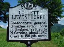
Confederate general, physician, author. Born in England, settled in North Carolina about 1847. Grave is 150 yds. north.Plaque via North Carolina Highway Historical Marker Program, and is used with...
- ncmarkers
- north carolina
ELLIOTT DAINGERFIELD 1859-1932
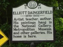
Artist, teacher, author. His paintings hang in the National Gallery, Metropolitan Museum, and other galleries. His home is here.Plaque via North Carolina Highway Historical Marker Program, and...
- ncmarkers
- north carolina
APPALACHIAN STATE UNIVERSITY
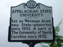
Est. 1899 as Watauga Academy by B.B. and D.D. Dougherty. A campus of The University of North Carolina since 1972.Plaque via North Carolina Highway Historical Marker Program, and is used with their...
- ncmarkers
- north carolina
ASA GRAY

American botanist and Harvard professor. In July, 1841, investigated flora of this region. He visited Roan Mountain, 12 miles north.Plaque via North Carolina Highway Historical Marker Program, and...
- ncmarkers
- north carolina
WALDENSES

A religious body dating from the Middle Ages. The town of Valdese was founded by members of this group in 1893.Plaque via North Carolina Highway Historical Marker Program, and is used with...
- ncmarkers
- north carolina