
MONTFORT STOKES 1762-1842

Governor, 1830-1832; U.S. Senator; Federal Indian Commissioner. Home stood 1 mi. N.Plaque via North Carolina Highway Historical Marker Program, and is used with their permission. Full page here...
- ncmarkers
- north carolina
J. P. CALDWELL

Editor of Statesville "Landmark" (1880-92), Charlotte "Observer" (1892-1909). His home was two blocks north.Plaque via North Carolina Highway Historical Marker Program, and is used with...
- ncmarkers
- north carolina
MITCHELL COLLEGE

Founded 1856 as college for women. Presbyterian until 1959. Granted state community college status, 1973. Two blocks N.Plaque via North Carolina Highway Historical Marker Program, and is used with...
- ncmarkers
- north carolina
EBENEZER ACADEMY
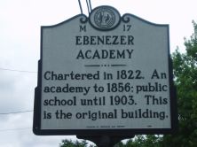
Chartered in 1822. An academy to 1856; public school until 1903. This is the original building.Plaque via North Carolina Highway Historical Marker Program, and is used with their permission. Full...
- ncmarkers
- north carolina
NORTH CAROLINA- VIRGINIA

NORTH CAROLINA / Colonized, 1585-87, by first English settlers in America; permanently settled c. 1650; first to vote readiness for independence, Apr. 12, 1776 b/w VIRGINIA / First...
- ncmarkers
- north carolina
NORTH CAROLINA- VIRGINIA

NORTH CAROLINA / Colonized, 1585-87, by first English settlers in America; permanently settled c. 1650; first to vote readiness for independence, Apr. 12, 1776 b/w VIRGINIA / First...
- ncmarkers
- north carolina
NORTH CAROLINA- VIRGINIA

NORTH CAROLINA / Colonized, 1585-87, by first English settlers in America; permanently settled c. 1650; first to vote readiness for independence, Apr. 12, 1776 b/w VIRGINIA / First...
- ncmarkers
- north carolina
JAMES B. GORDON

Brigadier general in the Confederate States Army. Mortally wounded near Richmond, Virginia, May 12, 1864. Birthplace stands 300 yards north.Plaque via North Carolina Highway Historical Marker...
- ncmarkers
- north carolina
RICHMOND PEARSON 1805-1878

Chief Justice of State Supreme Court, 1859-78. Conducted law school at Richmond Hill, his home, located 5 mi. NW.Plaque via North Carolina Highway Historical Marker Program, and is used with...
- ncmarkers
- north carolina
STONEMAN'S RAID

On a raid through western North Carolina Gen. Stoneman's U.S. cavalry occupied Statesville, April 13, 1865.Plaque via North Carolina Highway Historical Marker Program, and is used with...
- ncmarkers
- north carolina
STONEMAN'S RAID

On a raid through western North Carolina Gen. Stoneman's U.S. cavalry occupied Wilkesboro, March 29, 1865.Plaque via North Carolina Highway Historical Marker Program, and is used with...
- ncmarkers
- north carolina
FORT DOBBS
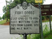
Built in 1756 by colony. Was garrisoned by North Carolina Provincials during French & Indian War, until 1762. Site 1 mi. N.Plaque via North Carolina Highway Historical Marker Program, and is...
- ncmarkers
- north carolina
GOLD MINES

Charlotte was center of region's gold rush after 1825. Rudisill & Saint Catherine, among largest mines, were near here.Plaque via North Carolina Highway Historical Marker Program, and is used with...
- ncmarkers
- north carolina
GOLD MINES

Charlotte was center of region's gold rush after 1825. Rudisill & Saint Catherine, among largest mines, were near here.Plaque via North Carolina Highway Historical Marker Program, and is used with...
- ncmarkers
- north carolina
BARRINGER MINE

Gold discovery in 1825 by Mathias Barringer launched the state's subsurface gold mining industry. Site 2 mi. W.Plaque via North Carolina Highway Historical Marker Program, and is used with their...
- ncmarkers
- north carolina
HARDAWAY SITE

Archaeological site key to understanding earliest native population. Its occupation dates to ca. 10,000 B.C. One mi. N.E.Plaque via North Carolina Highway Historical Marker Program, and is...
- ncmarkers
- north carolina
CHARLES A. CANNON 1892-1971

Cannon Mills president, 1921-1962; advanced the marketing of textiles. Civic leader and health care benefactor. Grave is one mile south.Plaque via North Carolina Highway Historical Marker Program,...
- ncmarkers
- north carolina
L'ALUMINIUM FRANCAIS

French company in 1913 began Narrows Dam and town named for Adrien Badin, president Southern Aluminum, a subsidiary. Office stood 1/2 mi. N.W.Plaque via North Carolina Highway Historical Marker...
- ncmarkers
- north carolina
DAVIE'S ATTACK
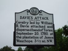
Cavalry led by William R. Davie attacked and dispersed band of Tories, September 20, 1780, at the plantation of James Wauchope, 3-1/2 mi. NW.Plaque via North Carolina Highway Historical Marker...
- ncmarkers
- north carolina
ISRAEL PICKENS 1780-1827

Congressman from N.C., 1811-1817. Moved to Alabama where he was governor, 1821-1825, & U.S. Senator. Born 2 mi. SW.Plaque via North Carolina Highway Historical Marker Program, and is used with...
- ncmarkers
- north carolina