
ANDRE MICHAUX
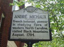
French botanist, pioneer in studying flora of western North Carolina, visited Black Mountains, August, 1794.Plaque via North Carolina Highway Historical Marker Program, and is used with...
- ncmarkers
- north carolina
LOCKE CRAIG

1860-1924 Governor, 1913-1917. He created the state highway & fisheries commissions, est. Mt. Mitchell State Park. Lived 1/2 mi. W.Plaque via North Carolina Highway Historical Marker Program, and...
- ncmarkers
- north carolina
HOT SPRINGS
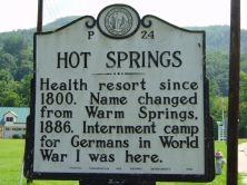
Health resort since 1800. Name changed from Warm Springs, 1886. Internment camp for Germans in World War I was here.Plaque via North Carolina Highway Historical Marker Program, and is used with...
- ncmarkers
- north carolina
VANCE-CARSON DUEL

On Nov. 5, 1827, Robert B. Vance, former N.C. Congressman, was fatally wounded in a duel by Samuel P. Carson, his successor. 1/2 mile S.E.Plaque via North Carolina Highway Historical Marker...
- ncmarkers
- north carolina
FELIX WALKER

Revolutionary officer, member Congress, 1817-23, where, in "talking for Buncombe" (County), he gave new meaning to the word. Home was 1/2 mi. N.Plaque via North Carolina Highway Historical...
- ncmarkers
- north carolina
PAINT ROCK

Pictographs on cliff face were created by Indians ca. 2500 B.C. & long have been landmark for travelers. 5 1/2 mi. N.W.Plaque via North Carolina Highway Historical Marker Program, and is used with...
- ncmarkers
- north carolina
GUN SHOP AND FORGE

Iron works set up four mi. W. by Philip Sitton after 1804. Source for manufacture of rifles by Philip Gillespie. Both operated to 1860s.Plaque via North Carolina Highway Historical Marker Program,...
- ncmarkers
- north carolina
LEE'S SCHOOL 1846-1879
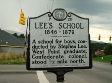
A school for boys, conducted by Stephen Lee, West Point graduate, Confederate colonel, stood 1/2 mile north.Plaque via North Carolina Highway Historical Marker Program, and is used with...
- ncmarkers
- north carolina
RIVERSIDE CEMETERY
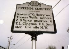
Graves of Thomas Wolfe & "O. Henry," authors; Zebulon B. Vance, governor; Thomas L. Clingman and Robert R. Reynolds, U.S. senators. One-half mile W.Plaque via North Carolina Highway...
- ncmarkers
- north carolina
FORSTER A. SONDLEY 1857-1931

Historian, lawyer, and bibliophile. Gave to Asheville the Sondley Reference Library. His home is 2.7 mi. north.Plaque via North Carolina Highway Historical Marker Program, and is used with...
- ncmarkers
- north carolina
ST. JOHN IN THE WILDERNESS

Episcopal Church, built 1833-34 as a private chapel. Given to Diocese of North Carolina, 1836. Enlarged in 1852.Plaque via North Carolina Highway Historical Marker Program, and is used with...
- ncmarkers
- north carolina
JETER C. PRITCHARD

United States Senator, 1895-1903, Republican leader, newspaperman, federal judge. His home is 3/10 mile east; grave is 1.3 mi. west.Plaque via North Carolina Highway Historical Marker Program, and...
- ncmarkers
- north carolina
FRANCIS ASBURY

Bishop of the Methodist Episcopal Church, 1784-1816, often visited and preached at the home of Daniel Killian which was one mile east.Plaque via North Carolina Highway Historical Marker Program,...
- ncmarkers
- north carolina
MARS HILL COLLEGE

Baptist; coeducational. Founded 1856 as French Broad Baptist Institute. Name changed 1859. Senior college since 1962.Plaque via North Carolina Highway Historical Marker Program, and is used with...
- ncmarkers
- north carolina
DR. L. B. McBRAYER

Leader in fight against tuberculosis in North Carolina, Superintendent of State Sanatorium in Hoke County, 1914-24. His birthplace is 400 ft. W.Plaque via North Carolina Highway Historical Marker...
- ncmarkers
- north carolina
RICHMOND PEARSON 1852-1923

Congressman, 1895-1901; U.S. Minister to Persia, 1902-07, and to Greece and Montenegro, 1907-09. His home, "Richmond Hill," was 1/2 mile N.W.Plaque via North Carolina Highway Historical...
- ncmarkers
- north carolina
RUTHERFORD TRACE

The expedition led by Gen. Griffith Rutherford against the Cherokee, September, 1776, passed nearby on the banks of the Swannanoa River.Plaque via North Carolina Highway Historical Marker Program,...
- ncmarkers
- north carolina
RUTHERFORD TRACE

The expedition led by Gen. Griffith Rutherford against the Cherokee, Sept., 1776, passed nearby.Plaque via North Carolina Highway Historical Marker Program, and is used with their permission. Full...
- ncmarkers
- north carolina
RUTHERFORD TRACE

The expedition led by Gen. Griffith Rutherford against the Cherokee, Sept., 1776, camped nearby along Hominy Creek.Plaque via North Carolina Highway Historical Marker Program, and is used with...
- ncmarkers
- north carolina
C. G. MEMMINGER

Secretary of the treasury of the Confederacy, from Charleston. Native of Germany. Summer home and grave nearby.Plaque via North Carolina Highway Historical Marker Program, and is used with...
- ncmarkers
- north carolina