

EDWARD WARREN

Born in Tyrrell County, 1828, Surgeon General of N.C., 1862-65, Professor of Surgery in Maryland, Chief Surgeon of Egypt, Died in Paris.Plaque via North Carolina Highway Historical Marker...
- ncmarkers
- north carolina
BURNING OF WASHINGTON

The town was burned and shelled by evacuating United States troops in April, 1864.Plaque via North Carolina Highway Historical Marker Program, and is used with their permission. Full page here (NC...
- ncmarkers
- north carolina
FORT HUGER

Principal Confederate fort on Roanoke Island. Mounted twelve guns. Surrendered Feb. 8, 1862. Earthworks are 100 yards south.Plaque via North Carolina Highway Historical Marker Program, and is used...
- ncmarkers
- north carolina
ATTACK ON WASHINGTON

Town seized by Union troops, Mar. 1862. Efforts to recapture it failed in 1862 & 1863. Union Army withdrew in Apr. 1864.Plaque via North Carolina Highway Historical Marker Program, and is...
- ncmarkers
- north carolina
FORT BRANCH

Confederate fort at Rainbow Banks, built to protect railroads and the upper Roanoke River valley. Earthworks remain. 3 miles northeast.Plaque via North Carolina Highway Historical Marker Program,...
- ncmarkers
- north carolina
DR. SUSAN DIMOCK

Native of Washington, Zurich graduate, head of a Boston hospital, 1st woman member N.C. Medical Society, 1872. Her girlhood home was here.Plaque via North Carolina Highway Historical...
- ncmarkers
- north carolina
JAMES JOHNSTON PETTIGREW

Confederate General, famed for charge at Gettysburg. His grave is 8 miles south.Plaque via North Carolina Highway Historical Marker Program, and is used with their permission. Full page here (NC...
- ncmarkers
- north carolina
RAM ALBEMARLE

Confederate ironclad, winner of notable victories under Capt. J. W. Cooke, was sunk 600 feet north, night of Oct. 27, 1864.Plaque via North Carolina Highway Historical Marker Program, and is...
- ncmarkers
- north carolina
FIRST ENGLISH COLONIES

Explored in 1584. Site of first English settlements in new world, 1585-1587. Birthplace of Virginia Dare, first child born of English parents in America.Plaque via North Carolina...
- ncmarkers
- north carolina
SAMUEL JOHNSTON

Revolutionary leader, Governor, U.S. Senator. His home, "Hayes," and grave are one mile S.E.Plaque via North Carolina Highway Historical Marker Program, and is used with their permission....
- ncmarkers
- north carolina
ROBERT LEE VANN 1879-1940

African American editor, lawyer, and civil rights advocate. Led Pittsburgh Courier, 1910-1940. He was born 4 miles east.Plaque via North Carolina Highway Historical Marker Program, and is...
- ncmarkers
- north carolina
W. O. SAUNDERS 1884-1940
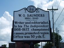
Writer and editorialist. In his The Independent, 1908-1937, championed causes, promoted region. Office was 50 yds. E.Plaque via North Carolina Highway Historical Marker Program, and is used with...
- ncmarkers
- north carolina
OLD NECK FRIENDS MEETING

Quaker meeting was established by 1680. Site of Yearly Meeting, 1698-1785. Discontinued, 1797. Building was 1 mile S.E.Plaque via North Carolina Highway Historical Marker Program, and is used with...
- ncmarkers
- north carolina
LEMUEL W. BOONE 1827-1878
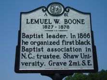
Baptist leader. In 1866 he organized first black Baptist association in N.C.; trustee, Shaw University. Grave 2 mi. SE.Plaque via North Carolina Highway Historical Marker Program, and is used with...
- ncmarkers
- north carolina
HUGH CALE 1835-1910

Sponsored the 1891 bill to establish present-day Elizabeth City State University; legislator, 1876-80, 1885, 1891. His grave is 6/10 mile west.Plaque via North Carolina Highway Historical Marker...
- ncmarkers
- north carolina
BATTLE OF SOUTH MILLS

Confederates, on Apr. 19, 1862, repelled Union army here, prevented demolition of Dismal Swamp Canal locks three miles N.W.Plaque via North Carolina Highway Historical Marker Program, and is used...
- ncmarkers
- north carolina
QUAKER ACTIVITY
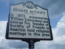
In 1672 missionaries William Edmundson and George Fox, founder of Society of Friends in America, held religious meetings in this area.Plaque via North Carolina Highway Historical Marker...
- ncmarkers
- north carolina
INGLIS FLETCHER 1879-1969

Novelist. Wrote Raleigh's Eden (1940), first of 12-volume "Carolina Series," based on early N.C. history. Her home, "Bandon," stood 1/2 mile northwest.Plaque via North Carolina Highway Historical...
- ncmarkers
- north carolina
MEHERRIN TOWN
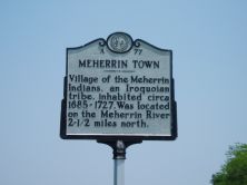
Village of the Meherrin Indians, an Iroquoian tribe, inhabited circa 1685-1727. Was located on the Meherrin River 2 1/2 miles north.Plaque via North Carolina Highway Historical Marker Program, and...
- ncmarkers
- north carolina
ALBEMARLE AND CHESAPEAKE CANAL

Constructed 1855-59 by steam dredges to assist commerce. Now part of Intracoastal Waterway. N.C. Cut 5 miles long.Plaque via North Carolina Highway Historical Marker Program, and is used with...
- ncmarkers
- north carolina