

EDWIN A. ALDERMAN

Crusader for education. President, UNC, 1896-1900; Tulane, 1900-04; Virginia, 1904-31. This was his birthplace.Plaque via North Carolina Highway Historical Marker Program, and is used with...
- ncmarkers
- north carolina
STAMP ACT

Resisted by armed band, Feb., 1766, at Brunswick, where Royal Governor Tryon lived. Site 18-3/4 mi. south.Plaque via North Carolina Highway Historical Marker Program, and is used with their...
- ncmarkers
- north carolina
THOMAS F. PRICE

Roman Catholic priest, pioneer Home Missionary of N.C. Co-founder of "Maryknoll Fathers," a foreign mission society. Birthplace (1860) 1 bl. E.Plaque via North Carolina Highway Historical...
- ncmarkers
- north carolina
MARY BAKER GLOVER EDDY

Founder of Christian Science Church. Spent part of 1844 at Hanover House, 2 blocks west.Plaque via North Carolina Highway Historical Marker Program, and is used with their permission. Full page...
- ncmarkers
- north carolina
CAPTAIN JOHNSTON BLAKELEY

After many victories, War of 1812, was lost at sea with his ship. Home was 2 blocks W.Plaque via North Carolina Highway Historical Marker Program, and is used with their permission. Full page...
- ncmarkers
- north carolina
GEORGE DAVIS 1820-1896

Confederate senator, 1862-64, and attorney general, 1864-65. Home was 2 blocks E.; grave is 1/2 mile northeast.Plaque via North Carolina Highway Historical Marker Program, and is used with their...
- ncmarkers
- north carolina
GEORGE DAVIS
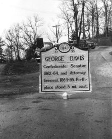
Confederate Senator, 1862-64, and Attorney General, 1864-65. Birthplace stood 3 mi. east.Plaque via North Carolina Highway Historical Marker Program, and is used with their permission. Full page...
- ncmarkers
- north carolina
WELSH TRACT

About 1730 a group of Welsh from the colony of Pennsylvania settled in this area, between the Northeast and Cape Fear rivers.Plaque via North Carolina Highway Historical Marker Program, and...
- ncmarkers
- north carolina
STAG PARK

Named by Barbadian explorers, 1663. Home of Gov. George Burrington and Samuel Strudwick, colonial official. The house stood 3/4 mi. E.Plaque via North Carolina Highway Historical Marker...
- ncmarkers
- north carolina
GEORGE BURRINGTON ca. 1682-1759

Colonial governor, 1724-1725, 1731-1734; opened lower Cape Fear region to settlement. His home was 3/4 mile east.Plaque via North Carolina Highway Historical Marker Program, and is used with...
- ncmarkers
- north carolina
WOODROW WILSON
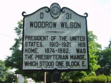
President of the United States, 1913-1921. His home, 1874-1882, was the Presbyterian manse, which stood one block E.Plaque via North Carolina Highway Historical Marker Program, and is used with...
- ncmarkers
- north carolina
FIRST POST ROAD

The road from New England to Charleston, over which mail was first carried regularly in North Carolina, 1738-39, passed near this spot.Plaque via North Carolina Highway Historical Marker Program,...
- ncmarkers
- north carolina
ORTON

Fine colonial home, built about 1725 by Roger Moore. Later Gov. Benjamin Smith's home. Stands 16-3/4 mi. south.Plaque via North Carolina Highway Historical Marker Program, and is used with...
- ncmarkers
- north carolina
NORTH CAROLINA-SOUTH CAROLINA

NORTH CAROLINA / Colonized, 1585-87, by first English settlers in America; permanently settled c. 1650; first to vote readiness for independence, Apr. 12, 1776 b/w SOUTH CAROLINA / Formed in...
- ncmarkers
- north carolina
NORTH CAROLINA-SOUTH CAROLINA
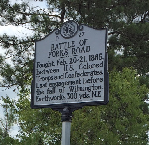
Fought, Feb. 20-21, 1865, between U.S. Colored Troops and Confederates. Last engagement before the fall of Wilmington. Earthworks 300 yds. N.E.Plaque via North Carolina Highway Historical Marker...
- ncmarkers
- north carolina
JAMES MOORE

Commander of Whigs in Moore's Creek campaign, 1776, brigadier general North Carolina troops at Charleston. Died 1777. His home was 3 mi. S.E.Plaque via North Carolina Highway Historical Marker...
- ncmarkers
- north carolina
ALFRED MOORE

Associate Justice United States Supreme Court, 1799-1804, officer in the Revolution, state attorney general, judge. Home was 18 3/4 mi. S.Plaque via North Carolina Highway Historical Marker...
- ncmarkers
- north carolina
ROBERT HOWE
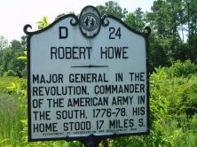
Major general in the Revolution, commander of the American Army in the South, 1776-78. His home stood 17 miles S.Plaque via North Carolina Highway Historical Marker Program, and is used with...
- ncmarkers
- north carolina
STATE SALT WORKS

The state of North Carolina to relieve a wartime scarcity, operated salt works from here to Myrtle Grove Sound, 1861-64.Plaque via North Carolina Highway Historical Marker Program, and is...
- ncmarkers
- north carolina
EARLY DRAWBRIDGE
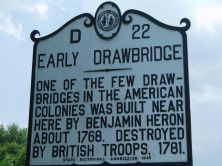
One of the few drawbridges in the American colonies was built near here by Benjamin Heron about 1768. Destroyed by British troops, 1781.Plaque via North Carolina Highway Historical Marker Program,...
- ncmarkers
- north carolina