

RUSSELLBOROUGH

Home of royal governors Dobbs and Tryon. Site of Stamp Act resistance in 1765. Burned in American Revolution.Plaque via North Carolina Highway Historical Marker Program, and is used with...
- ncmarkers
- north carolina
THOMAS F. WOOD 1841-1892

Organizer & Sec.-Treas. of State Board of Health, 1877-1892. Founded N.C. Medical Journal in 1878. Home was 1 block west.Plaque via North Carolina Highway Historical Marker Program, and is...
- ncmarkers
- north carolina
UNIVERSITY OF N.C. AT WILMINGTON

Est. 1947 as Wilmington College. Moved here in 1961. A campus of The University of North Carolina since 1969.Plaque via North Carolina Highway Historical Marker Program, and is used with...
- ncmarkers
- north carolina
FORT CASWELL
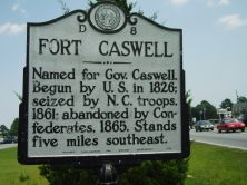
Named for Gov. Caswell. Begun by U.S. in 1826; seized by N.C. troops, 1861; abandoned by Confederates, 1865. Stands five miles southeast.Plaque via North Carolina Highway Historical Marker...
- ncmarkers
- north carolina
FORT CASWELL

Named for Gov. Caswell. Begun by U.S. in 1826; seized by N.C. troops, 1861; abandoned by Confederates, 1865. Stands five miles southeast.Plaque via North Carolina Highway Historical Marker...
- ncmarkers
- north carolina
BOUNDARY HOUSE

Commissioners met here to run boundary in 1764. Popular stop for colonial travelers. Ruins used to est. present state line in 1928. Located 2 3/4 mi. S.E.Plaque via North Carolina Highway...
- ncmarkers
- north carolina
ST. MARK'S
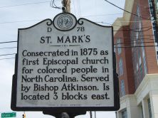
Consecrated in 1875 as first Episcopal church for colored people in North Carolina. Served by Bishop Atkinson. Is located 3 blocks east.Plaque via North Carolina Highway Historical Marker...
- ncmarkers
- north carolina
ST. STEPHEN A.M.E. CHURCH

Congregation formed in 1865. Present church constructed 1880 on land donated by Geo. Peabody. Located 2 blocks east.Plaque via North Carolina Highway Historical Marker Program, and is used with...
- ncmarkers
- north carolina
NORTH CAROLINA SOROSIS

Oldest Federated Women's Club in state; chartered 1896; organized in house 6 1/2 miles southwest.Plaque via North Carolina Highway Historical Marker Program, and is used with their permission....
- ncmarkers
- north carolina
WILMINGTON MORNING STAR

Established Sept. 23, 1867. Oldest daily newspaper in continuous publication in North Carolina. First office was 18 blocks N.W.Plaque via North Carolina Highway Historical Marker Program, and is...
- ncmarkers
- north carolina
MILLIE-CHRISTINE McKOY
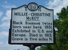
Black conjoined twins born near here, 1851. Exhibited in U.S. and Europe. Died in 1912. Grave is five miles N.Plaque via North Carolina Highway Historical Marker Program, and is used with...
- ncmarkers
- north carolina
JOHN LaPIERRE

Ordained 1707; came to America 1708. Served in many churches in area as missionary of Society for the Propagation of the Gospel, 1732-1755.Plaque via North Carolina Highway Historical...
- ncmarkers
- north carolina
JAMES HASELL

Acting governor, 1771; thrice Chief Justice, 1750-1766; President of the Council. Owned large library. Home 7 mi. S.E.Plaque via North Carolina Highway Historical Marker Program, and is used with...
- ncmarkers
- north carolina
CAPE FEAR CLUB

Founded in 1866; oldest men's social club in N.C. Guilford F. Dudley, first president. Building here in use since 1913.Plaque via North Carolina Highway Historical Marker Program, and is used with...
- ncmarkers
- north carolina
WASHINGTON'S SOUTHERN TOUR

President Washington, on April 27, 1791, was a guest at the home of William Gause, Jr., which stood four miles south.Plaque via North Carolina Highway Historical Marker Program, and is used with...
- ncmarkers
- north carolina
SAMUEL ASHE 1725-1813

Governor, 1795-1798; one of the first three state judges; president, Council of Safety, 1776. His grave is 3 miles east.Plaque via North Carolina Highway Historical Marker Program, and is...
- ncmarkers
- north carolina
OAKDALE CEMETERY

Est. in 1852. Includes graves of Confederate leaders, officers, and soldiers, & victims of yellow fever epidemic of 1862. Six blocks N.Plaque via North Carolina Highway Historical Marker Program,...
- ncmarkers
- north carolina
NICHOLAS N. NIXON 1800-1868

Planter. Developed peanut into profitable crop by scientific methods at his Porters Neck Plantation 2 miles east.Plaque via North Carolina Highway Historical Marker Program, and is used with...
- ncmarkers
- north carolina
CATHERINE KENNEDY HOME

For the elderly. Grew from Ladies Benevolent Society, founded, 1845. First home, 1879, stood four blocks east.Plaque via North Carolina Highway Historical Marker Program, and is used with...
- ncmarkers
- north carolina
BALD HEAD LIGHTHOUSE

Original lighthouse was erected in 1794. Present tower, "Old Baldy," built in 1817. Used until 1935. Stands 3 miles south.Plaque via North Carolina Highway Historical Marker Program, and is used...
- ncmarkers
- north carolina