

OCRACOKE LIGHTHOUSE

Oldest N.C. lighthouse still in service. Erected 1823 to serve Ocracoke Inlet trade. 75 ft. tall. Located 1/4 mile S.W.Plaque via North Carolina Highway Historical Marker Program, and is used with...
- ncmarkers
- north carolina
CAPE HATTERAS LIGHTHOUSE

Tallest brick lighthouse in nation at 208 feet. Constructed, 1869-1870, to mark Diamond Shoals. Replaced 1802 structure.Plaque via North Carolina Highway Historical Marker Program, and is...
- ncmarkers
- north carolina
RADIO MILESTONE
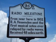
From near here in 1902 R. A. Fessenden sent the first musical notes ever relayed by radio waves. Received 48 miles north.Plaque via North Carolina Highway Historical Marker Program, and is...
- ncmarkers
- north carolina
FORT FORREST
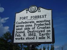
Confederate, mounting seven guns. Protected west side of Croatan Sound. Destroyed on Feb. 8, 1862. Earthworks stood 1 mile N.Plaque via North Carolina Highway Historical Marker Program, and...
- ncmarkers
- north carolina
JOHN GRAY BLOUNT 1752-1833

Merchant & land speculator. Shipping interests across eastern N.C.; also invested in western N.C. land. Home stood here.Plaque via North Carolina Highway Historical Marker Program, and is...
- ncmarkers
- north carolina
U.S.S. MONITOR

Fought C.S.S. "Virginia" ("Merrimac") in first battle of ironclad ships. Lost Dec. 31, 1862, in gale 17 miles southeast. First marine sanctuary.Plaque via North Carolina Highway Historical Marker...
- ncmarkers
- north carolina
CHRISTOPHER GALE ca. 1679-1735

Chief Justice of colony of North Carolina, 1712. Lived nearby at "Kirby Grange," his plantation.Plaque via North Carolina Highway Historical Marker Program, and is used with their permission. Full...
- ncmarkers
- north carolina
REHOBOTH CHURCH
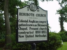
Colonial Anglican congregation known as Skinners Chapel. Present church constructed 1850-1853. Now United Methodist.Plaque via North Carolina Highway Historical Marker Program, and is used with...
- ncmarkers
- north carolina
ALEXANDER STEWART

Anglican minister to N.C., 1753-71. Served parish of St. Thomas & as chaplain to Gov. Arthur Dobbs. Erected first glebe house on record in the colony.Plaque via North Carolina Highway Historical...
- ncmarkers
- north carolina
EDWARD TEACH

Notorious pirate called "Blackbeard." Lived in Bath while Charles Eden was governor. Killed at Ocracoke, 1718.Plaque via North Carolina Highway Historical Marker Program, and is used with...
- ncmarkers
- north carolina
TRINITY CHURCH

Episcopal. Was originally Blount’s Chapel. Built nearby ca. 1774 by Rev. Nathaniel Blount, who served until his death, 1816. Moved here, 1939.Plaque via North Carolina Highway Historical Marker...
- ncmarkers
- north carolina
FLAT SWAMP CHURCH

Primitive Baptist. Begun in 1776. First pastor was John Page. Second building on site. Two miles S.Plaque via North Carolina Highway Historical Marker Program, and is used with their...
- ncmarkers
- north carolina
ANDREW CARTWRIGHT

Agent of the American Colonization Society in Liberia, founded the A.M.E. Zion churches in Albemarle area. His first church, 1865, near here.Plaque via North Carolina Highway Historical Marker...
- ncmarkers
- north carolina
LT. ROBERT MAYNARD
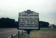
Of the Royal Navy. Sent by Gov. Spotswood of Virginia, in the sloop "Ranger," killed the pirate Blackbeard off shore, 1718.Plaque via North Carolina Highway Historical Marker Program, and is used...
- ncmarkers
- north carolina
MATTAMUSKEET
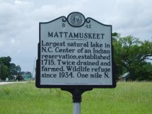
Largest natural lake in N.C. Center of an Indian reservation, established 1715. Twice drained and farmed. Wildlife refuge since 1934. One mile N.Plaque via North Carolina Highway Historical Marker...
- ncmarkers
- north carolina
DIAMOND SHOALS
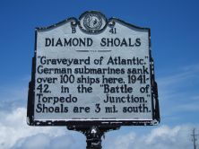
"Graveyard of Atlantic." German submarines sank over 100 ships here, 1941-42, in the "Battle of Torpedo Junction." Shoals are 3 mi. south.Plaque via North Carolina Highway Historical...
- ncmarkers
- north carolina
SKEWARKEY CHURCH

Baptist congregation formed about 1780. Primitive Baptist since 1830's. Church here was built in 1853.Plaque via North Carolina Highway Historical Marker Program, and is used with their...
- ncmarkers
- north carolina
WRIGHT BROTHERS

On December 17, 1903, from site near foot of Kill Devil Hill, Orville and Wilbur Wright made first successful powered flight 1/5 mile west.Plaque via North Carolina Highway Historical Marker...
- ncmarkers
- north carolina
CONFEDERATE FORTS

Fort Hatteras and Fort Clark, 2 miles s. west, fell to Union troops on Aug. 29, 1861, after two days of heavy naval bombardment.Plaque via North Carolina Highway Historical Marker Program, and...
- ncmarkers
- north carolina
COLINGTON ISLAND

Granted to Sir John Colleton, Sept. 8, 1663. Colonized in 1665 by a company under Peter Carteret. Two miles W.Plaque via North Carolina Highway Historical Marker Program, and is used with their...
- ncmarkers
- north carolina