
ELLEN BLACK WINSTON 1903-1984

Social worker. Led N.C. Board of Public Welfare, 1944-63; first Commissioner of U.S. Welfare. Her grave is 1/10 mi. W.Plaque via North Carolina Highway Historical Marker Program, and is used with...
- ncmarkers
- north carolina
JUNALUSKA ca. 1779-1858

Cherokee warrior, fought for U.S. in Creek War, 1814. Granted citizenship and land by N.C., 1847. Grave is one mile S.W.Plaque via North Carolina Highway Historical Marker Program, and is...
- ncmarkers
- north carolina
NORTH CAROLINA- GEORGIA

NORTH CAROLINA / Colonized, 1585-87, by first English settlers in America; permanently settled c. 1650; first to vote readiness for independence, Apr. 12, 1776 b/w GEORGIA / The colony of...
- ncmarkers
- north carolina
TSALI

Cherokee who resisted removal & escaped from U.S. troops; executed nearby, 1838. Story inspired Unto These Hills.Plaque via North Carolina Highway Historical Marker Program, and is used with...
- ncmarkers
- north carolina
INDIAN BOUNDARY

Near here the highway crosses Meigs-Freeman Line, surveyed in 1802, boundary between whites & Cherokees until 1819.Plaque via North Carolina Highway Historical Marker Program, and is used with...
- ncmarkers
- north carolina
NORTH CAROLINA- GEORGIA

NORTH CAROLINA / Colonized, 1585-87, by first English settlers in America; permanently settled c. 1650; first to vote readiness for independence, Apr. 12, 1776 b/w GEORGIA / The colony of...
- ncmarkers
- north carolina
POTTERY CLAY

Wedgwood potteries, England, used several tons of clay taken in 1767 from a nearby pit by Thomas Griffiths, a South Carolina planter.Plaque via North Carolina Highway Historical Marker...
- ncmarkers
- north carolina
GEORGE W. TRUETT

Pastor First Baptist Church, Dallas, Texas, 1897-1944, president of Baptist World Alliance. His birthplace stands one mile northwest.Plaque via North Carolina Highway Historical Marker Program,...
- ncmarkers
- north carolina
WESTERN CAROLINA UNIVERSITY

Established in 1889 as a private school. Has been a state supported institution since 1893.Plaque via North Carolina Highway Historical Marker Program, and is used with their permission. Full page...
- ncmarkers
- north carolina
COWEE

Principal settlement of the Cherokee Middle Towns. Council house stood on mound 300 yds. S. Town destroyed during the Revolution.Plaque via North Carolina Highway Historical Marker Program, and...
- ncmarkers
- north carolina
JUDACULLA ROCK

Soapstone boulder carved with Indian symbols between 500 & 1700 A.D. Sacred to the Cherokee. Petroglyphs 3 1/2 mi. SE.Plaque via North Carolina Highway Historical Marker Program, and is used with...
- ncmarkers
- north carolina
BAPTIST MISSION

For Cherokee Indians, established in 1817, consisting of a chapel, school, farm, and mills. Was 3 1/2 miles north.Plaque via North Carolina Highway Historical Marker Program, and is used with...
- ncmarkers
- north carolina
HORACE KEPHART

Author of "Our Southern Highlanders" (1913) and other works, naturalist, librarian. Grave 3/10 mi. S.W. Mt. Kephart, 30 mi. N., is named for him.Plaque via North Carolina Highway Historical Marker...
- ncmarkers
- north carolina
RUTHERFORD TRACE

The expedition led by Gen. Griffith Rutherford against the Cherokee, Sept., 1776, passed nearby along Savannah Creek.Plaque via North Carolina Highway Historical Marker Program, and is used with...
- ncmarkers
- north carolina
RUTHERFORD TRACE
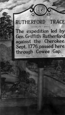
The expedition led by Gen. Griffith Rutherford against the Cherokee, Sept., 1776, passed nearby, through Cowee Gap.Plaque via North Carolina Highway Historical Marker Program, and is used with...
- ncmarkers
- north carolina
WILLIAM BARTRAM
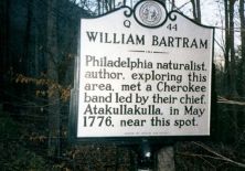
Philadelphia naturalist, author, exploring this area, met a Cherokee band led by their chief, Atakullakulla, in May 1776, near this spot.Plaque via North Carolina Highway Historical...
- ncmarkers
- north carolina
ECHOTA MISSION

Methodist. Maintained by Holston Conference for Cherokee c. 1840-1885. School established 1850. Missionary's house stands 50 yards north.Plaque via North Carolina Highway Historical...
- ncmarkers
- north carolina
WILLIAM H. THOMAS

White chief and agent of N.C. Cherokee. Secured reservation for them. Confederate colonel. State senator. Home, "Stekoih Fields," stood 1/4 mi. S.Plaque via North Carolina Highway...
- ncmarkers
- north carolina
LEWIS J. SMITH 1843-1901

A founder & benefactor of Cullowhee Academy, forerunner of Western Carolina University. Lived 2 miles north.Plaque via North Carolina Highway Historical Marker Program, and is used with...
- ncmarkers
- north carolina
ROBERT L. MADISON 1867-1954

Founder of Western Carolina University & its president, 1889-1912, & 1920-1923. Lived 5 mi. N.Plaque via North Carolina Highway Historical Marker Program, and is used with their permission. Full...
- ncmarkers
- north carolina