
FRIEDENS CHURCH

Lutheran. Congregation organized before 1791; church shared with other denominations until the 1850s. This bldg., 1940.Plaque via North Carolina Highway Historical Marker Program, and is used with...
- ncmarkers
- north carolina
MORATOCK FURNACE

Smelting furnace built by Nathaniel Moody in 1843. It supplied iron to Confederacy, 1862-1865. Stands 3/10 mi. NE.Plaque via North Carolina Highway Historical Marker Program, and is used with...
- ncmarkers
- north carolina
WASHINGTON'S SOUTHERN TOUR

President Washington spent night of May 31, 1791, at the tavern in Salem. 1/2 mile north.Plaque via North Carolina Highway Historical Marker Program, and is used with their permission. Full page...
- ncmarkers
- north carolina
CONE BROTHERS

Moses and Ceasar Cone pioneered marketing of textiles; manufactured denim & flannel. Their first mill, Proximity, 1895, was 1/4 mile N.E.Plaque via North Carolina Highway Historical Marker...
- ncmarkers
- north carolina
SPRINGFIELD FRIENDS MEETING

Established in 1773 and organized as a Monthly Meeting, 1790. Building erected 1927 on original site is 1/2 mile east.Plaque via North Carolina Highway Historical Marker Program, and is used with...
- ncmarkers
- north carolina
FIRST PUBLIC SCHOOL IN N.C.

First free school in the state, established under Common School Law of 1839, opened January 20, 1840, in this vicinity.Plaque via North Carolina Highway Historical Marker Program, and is used with...
- ncmarkers
- north carolina
CHARLIE POOLE 1892-1931

Pioneer country music recording artist. With N.C. Ramblers, 1918-31, popularized old-time music. Grave 1/2 mi. SW.Plaque via North Carolina Highway Historical Marker Program, and is used with...
- ncmarkers
- north carolina
EDWARD R. MURROW 1908-1965
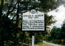
Radio correspondent in London during World War Two. Television interviewer & commentator. Born one mile east.Plaque via North Carolina Highway Historical Marker Program, and is used with...
- ncmarkers
- north carolina
LEAKSVILLE LANDING

Port for bateau trade on Dan River. Improved by Roanoke Navigation Company, 1820s. Ruins visible at low water. 200 yards west.Plaque via North Carolina Highway Historical Marker Program, and...
- ncmarkers
- north carolina
SLINK SHOAL SLUICE

Dan River improvements built 1820s by Roanoke Navigation Co. include sluice & wing dams 1/4 mi. E. Rebuilt, 1880s.Plaque via North Carolina Highway Historical Marker Program, and is used with...
- ncmarkers
- north carolina
SHALLOW FORD
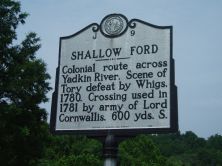
Colonial route across Yadkin River. Scene of Tory defeat by Whigs, 1780. Crossing used in 1781 by army of Lord Cornwallis. 600 yds. S.Plaque via North Carolina Highway Historical Marker...
- ncmarkers
- north carolina
GUILFORD COUNTY HEALTH DEPARTMENT

Established in 1911, it was the first county health department in N.C. and second in U.S. Now two blocks north.Plaque via North Carolina Highway Historical Marker Program, and is used with...
- ncmarkers
- north carolina
BARNETT CANAL

Built near here by James Barnett in 1813. Later powered largest continuously operating textile complex in the northern piedmont.Plaque via North Carolina Highway Historical Marker Program, and...
- ncmarkers
- north carolina
PALMER MEMORIAL INSTITUTE

Preparatory school for blacks founded 1902 by Charlotte Hawkins Brown. Named for Alice Freeman Palmer. Closed in 1971. Now state historic site.Plaque via North Carolina Highway Historical Marker...
- ncmarkers
- north carolina
ROBERT M. HANES 1890-1959
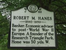
Banker. Economic adviser to post-World War II Europe. A founder of the Research Triangle Park. Home was 50 yds. W.Plaque via North Carolina Highway Historical Marker Program, and is used with...
- ncmarkers
- north carolina
PIEDMONT RAILROAD

Railroad line between Greensboro and Danville. Constructed, 1862-1864, for the Confederacy. Its terminus was nearby.Plaque via North Carolina Highway Historical Marker Program, and is used with...
- ncmarkers
- north carolina
MASONIC HOME

Established in 1912 by Grand Lodge of Masons and Order of Eastern Star for their aged.Plaque via North Carolina Highway Historical Marker Program, and is used with their permission. Full page...
- ncmarkers
- north carolina
NORTH CAROLINA SCHOOL OF THE ARTS

Est. 1963; opened 1965. First state-supported school for performing arts in U.S. A campus of The University of North Carolina since 1971.Plaque via North Carolina Highway Historical Marker...
- ncmarkers
- north carolina
CALCIUM CARBIDE

Industrial experiment nearby in 1892 led to discovery of process for its manufacture. First produced commercially by James T. Morehead.Plaque via North Carolina Highway Historical Marker Program,...
- ncmarkers
- north carolina
LINDSAY STREET SCHOOL

The first permanent public graded school in N.C. opened in 1875 in a building which stood on this site.Plaque via North Carolina Highway Historical Marker Program, and is used with their...
- ncmarkers
- north carolina