

FORT HANCOCK

Erected in 1778 by Le Chevalier de Cambray & Capt. de Cottineau to protect Cape Lookout Bay. Dismantled, 1780. Site four miles south.Plaque via North Carolina Highway Historical Marker...
- ncmarkers
- north carolina
'PROMETHEUS'

First steamboat made in N.C. Built in 1818 by Otway Burns, privateer in War of 1812. Shipyard located 350 feet S.W.Plaque via North Carolina Highway Historical Marker Program, and is used with...
- ncmarkers
- north carolina
GEORGE H. WHITE 1852-1918
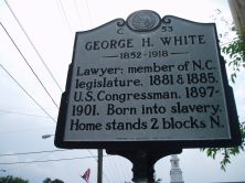
Lawyer; member of N.C. legislature, 1881 & 1885. U.S. Congressman, 1897-1901. Born into slavery. Home stands 2 blocks N.Plaque via North Carolina Highway Historical Marker Program, and is...
- ncmarkers
- north carolina
COL. JOHN STARKEY

Free school advocate, 1749; Southern District treasurer, 1750-1765; member of assembly for 25 years. Grave located at "The Bluff" 4 mi. N.Plaque via North Carolina Highway Historical...
- ncmarkers
- north carolina
BATCHELDER'S CREEK

Site of Union outpost captured by Confederate Generals Hoke & Pickett on February 1, 1864. The earthworks are 300 yards North.Plaque via North Carolina Highway Historical Marker Program, and...
- ncmarkers
- north carolina
FIRST PROVINCIAL CONGRESS

In America to be called and held in defiance of British orders met in this town, Aug. 25-27, 1774, with 71 delegates present.Plaque via North Carolina Highway Historical Marker Program, and...
- ncmarkers
- north carolina
ABNER NASH

Governor during British invasion, 1780-81. Member of Provincial and Continental Congresses. Grave 3 1/3 miles S.W.Plaque via North Carolina Highway Historical Marker Program, and is used with...
- ncmarkers
- north carolina
CONFEDERATE SALT WORKS

The largest Confederate salt works in Carteret County was 50 yards S. It was burned by Union forces in April, 1862.Plaque via North Carolina Highway Historical Marker Program, and is used with...
- ncmarkers
- north carolina
NORTH CAROLINA BANKERS ASSOCIATION

Organized at Teachers’ Assembly Hall, nearby, July 24, 1897. Thomas Battle, first president.Plaque via North Carolina Highway Historical Marker Program, and is used with their permission....
- ncmarkers
- north carolina
FIRST MOTORIZED SCHOOL BUS

On September 5, 1917, the Pamlico Co. School system inaugurated the first motorized school bus service in North Carolina.Plaque via North Carolina Highway Historical Marker Program, and is used...
- ncmarkers
- north carolina
HOFMANN FOREST

Named for J. V. Hofmann. Research forest of 80,000 acres in Jones & Onslow counties. Acquired, 1934, for use by North Carolina State University.Plaque via North Carolina Highway Historical...
- ncmarkers
- north carolina
F. M. SIMMONS

Congressman, 1887-1889; U.S. Senator, 1901-1931; Chairman of Finance, World War I. Birthplace is one-tenth mile.Plaque via North Carolina Highway Historical Marker Program, and is used with...
- ncmarkers
- north carolina
PORT SWANNSBOROUGH

Named for Samuel Swann. Town incorporated in 1783. Port, including area from New River to Bogue Inlet, established in 1786.Plaque via North Carolina Highway Historical Marker Program, and is used...
- ncmarkers
- north carolina
CHRIST CHURCH

Episcopal. Craven Parish created 1715. First Church erected 1750, this one in 1875. Communion service, given by George II, 1752, still in use. One block S.Plaque via North Carolina...
- ncmarkers
- north carolina
HUGGINS ISLAND FORT

Confederate 6-gun fort guarding the entrance to Bogue Inlet; burned by Union troops, Aug. 19, 1862. Remains, 1 mi. S.W.Plaque via North Carolina Highway Historical Marker Program, and is used with...
- ncmarkers
- north carolina
TEACHER'S ASSEMBLY (NORTH CAROLINA EDUCATION ASSN.)

Headquarters and annual meeting-place, 1888-1900; razed 1934. The building stood here.Plaque via North Carolina Highway Historical Marker Program, and is used with their permission. Full page...
- ncmarkers
- north carolina
OCRACOKE INLET

Once chief trade inlet of N.C. In 1718 pirate "Blackbeard" was killed near there, 17 mi. N.E., across Pamlico Sound.Plaque via North Carolina Highway Historical Marker Program, and is used with...
- ncmarkers
- north carolina
ONSLOW RAID

Federal gunboat Ellis attacked this town Nov. 23, 1862, then ran aground downstream. It was abandoned under Confederate crossfire.Plaque via North Carolina Highway Historical Marker Program, and...
- ncmarkers
- north carolina
LOT BALLARD HOUSE

Bishop Francis Asbury stopped there many times between 1799 and 1815 on visits to New River Chapel. House was 3/4 mi. W.Plaque via North Carolina Highway Historical Marker Program, and is used...
- ncmarkers
- north carolina
CORE SOUND MEETING

Quaker center for more than 100 yrs. after 1733. Migration west was one cause of decline. Meeting house was 50 yards W.Plaque via North Carolina Highway Historical Marker Program, and is used with...
- ncmarkers
- north carolina