
J. G. ARENDS

Native German, pioneer teacher and minister, ordained 1775, first president of the N.C. Lutheran Synod, 1803. Grave a few yds. east.Plaque via North Carolina Highway Historical Marker Program, and...
- ncmarkers
- north carolina
LENOIR RHYNE

Coeducational, Lutheran college, named for W. W. Lenoir and D. E. Rhyne. Opened as Lenoir College in academic year, 1891-92.Plaque via North Carolina Highway Historical Marker Program, and is used...
- ncmarkers
- north carolina
JOSEPH DICKSON 1745-1825
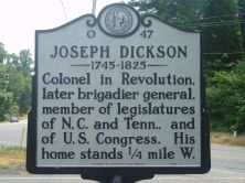
Colonel in Revolution, later brigadier general, member of legislatures of N.C. and Tenn., and of U.S. Congress. His home stands 1/4 mile W.Plaque via North Carolina Highway Historical...
- ncmarkers
- north carolina
CLYDE R. HOEY

United States Senator, 1945-54, congressman, governor, N.C. legislator, lawyer, editor. Home is 1 mi., grave 1.2 mi., N.E.Plaque via North Carolina Highway Historical Marker Program, and is used...
- ncmarkers
- north carolina
CATAWBA SPRINGS

Fashionable "watering place," a recreational and social center prior to 1861. The hotel stood five miles northeast.Plaque via North Carolina Highway Historical Marker Program, and is used with...
- ncmarkers
- north carolina
KINGS MOUNTAIN BATTLEGROUND

Site of decisive British defeat on Oct. 7, 1780. National Military Park located 5 mi. southeast in South Carolina.Plaque via North Carolina Highway Historical Marker Program, and is used with...
- ncmarkers
- north carolina
DALLAS

Named for G.M. Dallas. First seat of Gaston County, 1846-1911; site of Gaston College, now extinct. Courthouse built 1848 is here.Plaque via North Carolina Highway Historical Marker Program, and...
- ncmarkers
- north carolina
CATAWBA COLLEGE

Coeducational, liberal arts. Affiliated with Evangelical & Reformed Church. Opened 1/2 mi. N., 1851. Moved to Salisbury, 1925, & enlarged.Plaque via North Carolina Highway Historical...
- ncmarkers
- north carolina
'OLD BILL' WILLIAMS
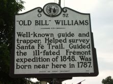
Well-known guide and trapper. Helped survey Santa Fe Trail. Guided the ill-fated Fremont expedition of 1848. Was born near here in 1787.Plaque via North Carolina Highway Historical Marker...
- ncmarkers
- north carolina
CLAREMONT COLLEGE
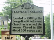
Founded in 1880 by the Evangelical & Reformed Church as a school for women. Closed in 1916. Stood 300 yards east.Plaque via North Carolina Highway Historical Marker Program, and is used with their...
- ncmarkers
- north carolina
JOHN FULENWIDER

Founder of High Shoals Iron Works about 1795. One of first producers of pig iron by charcoal process. Revolutionary patriot. Buried 20 yards W.Plaque via North Carolina Highway Historical Marker...
- ncmarkers
- north carolina
GRACE EVANGELICAL LUTHERAN CHURCH

Organized before 1797 by German settlers from Pennsylvania. Present building, erected 1950, stands 2 1/2 miles south.Plaque via North Carolina Highway Historical Marker Program, and is used with...
- ncmarkers
- north carolina
R. GREGG CHERRY

Governor of North Carolina, 1945-1949. State legislator. Promoted good roads and rural electrification. Grave is 3 miles S.E.Plaque via North Carolina Highway Historical Marker Program, and is...
- ncmarkers
- north carolina
BELMONT ABBEY COLLEGE

Roman Catholic. Liberal arts coeducational college. Founded, 1876, by Order of St. Benedict. One mile north.Plaque via North Carolina Highway Historical Marker Program, and is used with...
- ncmarkers
- north carolina
MACHPELAH CEMETERY

Presbyterian, 1801. Graves include those of Alexander Brevard, Joseph & James Graham, and Robert Hall & Joseph Graham Morrison.Plaque via North Carolina Highway Historical Marker Program, and is...
- ncmarkers
- north carolina