
STONEWALL JACKSON TRAINING SCHOOL

State juvenile facility. Est. in 1909 to provide boys with educational and vocational training. Campus is 200 yds. W.Plaque via North Carolina Highway Historical Marker Program, and is used with...
- ncmarkers
- north carolina
ST. LUKE'S EPISCOPAL CHURCH

Parish established in 1753. Present building constructed in 1828, stands one block west.Plaque via North Carolina Highway Historical Marker Program, and is used with their permission. Full page...
- ncmarkers
- north carolina
J. P. CALDWELL

Editor of Statesville "Landmark" (1880-92), Charlotte "Observer" (1892-1909). His home stood at this point.Plaque via North Carolina Highway Historical Marker Program, and is used with...
- ncmarkers
- north carolina
S. B. ALEXANDER

First president of N.C. Farmers' Alliance, 1887. Was N.C. senator & U.S. congressman. Advocate of agricultural education. Home is 1 block S.E.Plaque via North Carolina Highway Historical...
- ncmarkers
- north carolina
THIRD CREEK CHURCH

Presbyterian. Founded before 1789. Present building erected 1835. Stands 2 miles north.Plaque via North Carolina Highway Historical Marker Program, and is used with their permission. Full page...
- ncmarkers
- north carolina
D. H. HILL

Lieutenant General, C.S.A.; Supt. N.C. Military Institute in Charlotte; Davidson College professor; Editor, "The Land We Love." Grave is here.Plaque via North Carolina Highway Historical Marker...
- ncmarkers
- north carolina
JEFFERSON DAVIS

President, Confederate States of America, spent the night of April 18, 1865, in house which stood here.Plaque via North Carolina Highway Historical Marker Program, and is used with their...
- ncmarkers
- north carolina
NORTH CAROLINA-SOUTH CAROLINA

NORTH CAROLINA / Colonized, 1585-87, by first English settlers in America; permanently settled c. 1650; first to vote readiness for independence, Apr. 12, 1776 b/w SOUTH CAROLINA / Formed in...
- ncmarkers
- north carolina
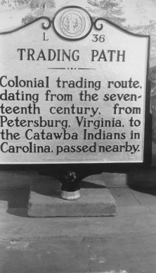
TRADING PATH

Colonial trading route, dating from the seventeenth century, from Petersburg, Virginia, to the Catawba Indians in Carolina, passed here.Plaque via North Carolina Highway Historical Marker Program,...
- ncmarkers
- north carolina
TRADING PATH
Colonial trading route, dating from the seventeenth century, from Petersburg, Virginia, to the Catawba Indians in Carolina, passed nearby.Plaque via North Carolina Highway Historical Marker...
- ncmarkers
- north carolina
TRADING PATH
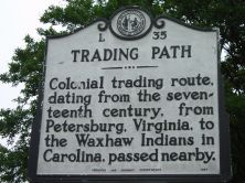
Colonial trading route, dating from the seventeenth century, from Petersburg, Virginia, to the Waxhaw Indians in Carolina, passed nearby.Plaque via North Carolina Highway Historical Marker...
- ncmarkers
- north carolina
TRADING PATH

Colonial trading route, dating from the seventeenth century, from Petersburg, Virginia, to the Waxhaw Indians in Carolina, passed nearby.Plaque via North Carolina Highway Historical Marker...
- ncmarkers
- north carolina
TRADING PATH
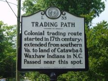
Colonial trading route started in 17th century; extended from southern Va. to land of Catawba & Waxhaw Indians in N.C. Passed near this spot.Plaque via North Carolina Highway Historical Marker...
- ncmarkers
- north carolina
FERDINAND FOCH
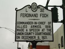
Commander-in-chief of Allied armies, 1918, made a speech at the Union County Courthouse, on December 9, 1921.Plaque via North Carolina Highway Historical Marker Program, and is used with...
- ncmarkers
- north carolina
JEFFERSON DAVIS

President Davis, moving southward after Lee's surrender, spent seven days, April 19-26, 1865, in a house which stood in this vicinity.Plaque via North Carolina Highway Historical Marker...
- ncmarkers
- north carolina
TRADING PATH
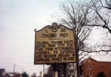
Colonial trading route dating from 17th century, from Petersburg, Virginia, to the Catawba and Waxhaw Indians in Carolina, passed nearby.Plaque via North Carolina Highway Historical...
- ncmarkers
- north carolina
CONFEDERATE CABINET
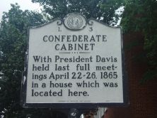
With President Davis held last full meetings April 22-26, 1865 in a house which was located here.Plaque via North Carolina Highway Historical Marker Program, and is used with their...
- ncmarkers
- north carolina
STONEMAN'S RAID

Stoneman's U.S. cavalry occupied the town of Salisbury, Apr. 12, 1865, and destroyed the Confederate warehouses, supplies, and prison.Plaque via North Carolina Highway Historical Marker Program,...
- ncmarkers
- north carolina
STONEMAN'S RAID

On their raid through western N. C., Gen. George Stoneman's U.S. cavalry fought a skirmish with Confederate troops near here, April 12, 1865.Plaque via North Carolina Highway Historical Marker...
- ncmarkers
- north carolina
LEE S. OVERMAN

United States Senator, 1903-30, a leading supporter of Wilson's war policies, Speaker of House of Representatives. His home is here.Plaque via North Carolina Highway Historical Marker Program, and...
- ncmarkers
- north carolina