

FIRST PUBLIC LIBRARY

In North Carolina was set up near this spot about 1700. Books sent from England by Rev. Thos. Bray.Plaque via North Carolina Highway Historical Marker Program, and is used with their...
- ncmarkers
- north carolina
BATTLE OF PLYMOUTH

Confederate troops led by Gen. Robert F. Hoke, aided by ram Albemarle, retook Union-occupied town, April 17-20, 1864.Plaque via North Carolina Highway Historical Marker Program, and is used with...
- ncmarkers
- north carolina
PALMER-MARSH HOUSE

Plaque via North Carolina Highway Historical Marker Program, and is used with their permission. Full page here (NC Marker ID BB3)
- ncmarkers
- north carolina
HISTORIC BATH

Plaque via North Carolina Highway Historical Marker Program, and is used with their permission. Full page here (NC Marker ID BB2)
- ncmarkers
- north carolina
PALMER-MARSH HOUSE

Plaque via North Carolina Highway Historical Marker Program, and is used with their permission. Full page here (NC Marker ID BB3)
- ncmarkers
- north carolina
CIVIL AIR PATROL
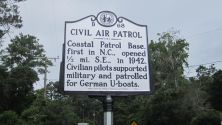
Coastal Patrol Base, first in N.C., opened ½ mi. S.E., in 1942. Civilian pilots supported military and patrolled for German U-boats.Plaque via North Carolina Highway Historical Marker Program, and...
- ncmarkers
- north carolina
GRANVILLE GRANT

Formed northern half of colony of North Carolina. Its southern boundary was surveyed in 1743 to a point near here.Plaque via North Carolina Highway Historical Marker Program, and is used with...
- ncmarkers
- north carolina
GRANVILLE GRANT

Formed northern half of colony of North Carolina. Survey of southern boundary began 28 1/2 miles east across sound, 1743.Plaque via North Carolina Highway Historical Marker Program, and is...
- ncmarkers
- north carolina
SOMERSET PLACE

Antebellum plantation of Josiah Collins III, who grew rice & corn. Home in 1860 to 328 slaves. Located six miles south.Plaque via North Carolina Highway Historical Marker Program, and is used with...
- ncmarkers
- north carolina
JAMES ADAMS FLOATING THEATRE

Toured coastal towns, 1913-1941. Edna Ferber's 1925 visit to ship, then docked nearby, was basis for her novel Show Boat.Plaque via North Carolina Highway Historical Marker Program, and is...
- ncmarkers
- north carolina
OCRACOKE LIGHTHOUSE

Oldest N.C. lighthouse still in service. Erected 1823 to serve Ocracoke Inlet trade. 75 ft. tall. Located 1/4 mile S.W.Plaque via North Carolina Highway Historical Marker Program, and is used with...
- ncmarkers
- north carolina
CAPE HATTERAS LIGHTHOUSE

Tallest brick lighthouse in nation at 208 feet. Constructed, 1869-1870, to mark Diamond Shoals. Replaced 1802 structure.Plaque via North Carolina Highway Historical Marker Program, and is...
- ncmarkers
- north carolina
RADIO MILESTONE
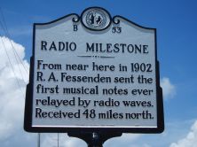
From near here in 1902 R. A. Fessenden sent the first musical notes ever relayed by radio waves. Received 48 miles north.Plaque via North Carolina Highway Historical Marker Program, and is...
- ncmarkers
- north carolina
FORT FORREST
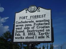
Confederate, mounting seven guns. Protected west side of Croatan Sound. Destroyed on Feb. 8, 1862. Earthworks stood 1 mile N.Plaque via North Carolina Highway Historical Marker Program, and...
- ncmarkers
- north carolina
JOHN GRAY BLOUNT 1752-1833

Merchant & land speculator. Shipping interests across eastern N.C.; also invested in western N.C. land. Home stood here.Plaque via North Carolina Highway Historical Marker Program, and is...
- ncmarkers
- north carolina
U.S.S. MONITOR

Fought C.S.S. "Virginia" ("Merrimac") in first battle of ironclad ships. Lost Dec. 31, 1862, in gale 17 miles southeast. First marine sanctuary.Plaque via North Carolina Highway Historical Marker...
- ncmarkers
- north carolina
CHRISTOPHER GALE ca. 1679-1735

Chief Justice of colony of North Carolina, 1712. Lived nearby at "Kirby Grange," his plantation.Plaque via North Carolina Highway Historical Marker Program, and is used with their permission. Full...
- ncmarkers
- north carolina
REHOBOTH CHURCH
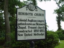
Colonial Anglican congregation known as Skinners Chapel. Present church constructed 1850-1853. Now United Methodist.Plaque via North Carolina Highway Historical Marker Program, and is used with...
- ncmarkers
- north carolina
ALEXANDER STEWART

Anglican minister to N.C., 1753-71. Served parish of St. Thomas & as chaplain to Gov. Arthur Dobbs. Erected first glebe house on record in the colony.Plaque via North Carolina Highway Historical...
- ncmarkers
- north carolina
EDWARD TEACH

Notorious pirate called "Blackbeard." Lived in Bath while Charles Eden was governor. Killed at Ocracoke, 1718.Plaque via North Carolina Highway Historical Marker Program, and is used with...
- ncmarkers
- north carolina