

DIAMOND SHOALS
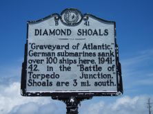
"Graveyard of Atlantic." German submarines sank over 100 ships here, 1941-42, in the "Battle of Torpedo Junction." Shoals are 3 mi. south.Plaque via North Carolina Highway Historical...
- ncmarkers
- north carolina
SKEWARKEY CHURCH

Baptist congregation formed about 1780. Primitive Baptist since 1830's. Church here was built in 1853.Plaque via North Carolina Highway Historical Marker Program, and is used with their...
- ncmarkers
- north carolina
WRIGHT BROTHERS

On December 17, 1903, from site near foot of Kill Devil Hill, Orville and Wilbur Wright made first successful powered flight 1/5 mile west.Plaque via North Carolina Highway Historical Marker...
- ncmarkers
- north carolina
CONFEDERATE FORTS

Fort Hatteras and Fort Clark, 2 miles s. west, fell to Union troops on Aug. 29, 1861, after two days of heavy naval bombardment.Plaque via North Carolina Highway Historical Marker Program, and...
- ncmarkers
- north carolina
COLINGTON ISLAND

Granted to Sir John Colleton, Sept. 8, 1663. Colonized in 1665 by a company under Peter Carteret. Two miles W.Plaque via North Carolina Highway Historical Marker Program, and is used with their...
- ncmarkers
- north carolina
C. C. CAMBRELENG

Congressman from New York, 1821-39; House leader for Jackson & Van Buren; minister to Russia; merchant. Was born in this town, 1786.Plaque via North Carolina Highway Historical Marker Program, and...
- ncmarkers
- north carolina
LAKE COMPANY

Josiah Collins, Sr., and partners drained part of 100,000-acre tract near Lake Phelps with 6-mile canal, completed 1788; mouth 2 mi. southeast.Plaque via North Carolina Highway Historical Marker...
- ncmarkers
- north carolina
ROANOKE RIVER

Early channel of trade, its valley long an area of plantations. Frequent floods until 1952, since controlled by Kerr Dam. Old name was "Moratuck."Plaque via North Carolina Highway Historical...
- ncmarkers
- north carolina
DANIEL G. FOWLE
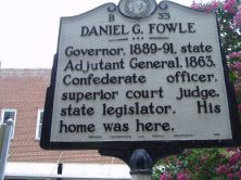
Governor, 1889-91, state Adjutant General, 1863, Confederate officer, superior court judge, state legislator. His home stood here.Plaque via North Carolina Highway Historical Marker Program, and...
- ncmarkers
- north carolina
WRECK OF THE U.S.S. 'HURON'

Steamer ran aground on November 24, 1877, near here, killing 98. Tragedy led to improvements in U.S. Livesaving Service.Plaque via North Carolina Highway Historical Marker Program, and is...
- ncmarkers
- north carolina
'MIRLO' RESCUE

A German submarine sank the British tanker "Mirlo" off coast nearby, Aug. 16, 1918. Coast Guard, led by J. A. Midgett, saved most of the crew.Plaque via North Carolina Highway Historical...
- ncmarkers
- north carolina
ST. THOMAS CHURCH

Episcopal. Oldest church building in the state of North Carolina; was constructed in 1734.Plaque via North Carolina Highway Historical Marker Program, and is used with their permission. Full page...
- ncmarkers
- north carolina
CHARLES PETTIGREW

First Bishop-elect of Episcopal Church in N.C., 1794. St. David's Church, erected 1803 at his expense, and his home are 1/2 mile southeast.Plaque via North Carolina Highway Historical Marker...
- ncmarkers
- north carolina
DeMILLE FAMILY

Home of motion picture producer Cecil B. DeMille & his father, playwright Henry C. DeMille, stood five blocks west.Plaque via North Carolina Highway Historical Marker Program, and is used with...
- ncmarkers
- north carolina
MATTHEW ROWAN

Acting governor, 1753-54. Councilor, assemblyman, and Surveyor-General. Merchant in the Irish trade. His home was here.Plaque via North Carolina Highway Historical Marker Program, and is used with...
- ncmarkers
- north carolina
R. A. FESSENDEN

Inventor, Pioneer in radio communication, conducted wireless experiments, 1901-02, from a station, 600 yds. S.W.Plaque via North Carolina Highway Historical Marker Program, and is used with their...
- ncmarkers
- north carolina
JOHN F. TOMPKINS

Agricultural reformer, a founder of the State Fair, published and edited the "Farmer's Journal," 1852-53, in Bath. This was his home.Plaque via North Carolina Highway Historical Marker...
- ncmarkers
- north carolina
JOSEPHUS DANIELS

Secretary of the Navy, 1913-21; Ambassador to Mexico; editor; author. Birthplace stood here.Plaque via North Carolina Highway Historical Marker Program, and is used with their permission. Full...
- ncmarkers
- north carolina
AUGUSTIN DALY

Playwright, dramatic critic, theatrical producer, and actor, was born, July 20, 1838, in a house which stood 300 feet north.Plaque via North Carolina Highway Historical Marker Program, and is used...
- ncmarkers
- north carolina
BUNCOMBE HALL

Continental Line officer. Wounded and captured at Germantown, Oct. 1777. Home, “Buncombe Hall,” stood one mile north.Plaque via North Carolina Highway Historical Marker Program, and is used with...
- ncmarkers
- north carolina