

FLAT ROCK

Landmark for Indians and the pioneer white settlers of this area, lies nearby. Town of Flat Rock named for this natural formation.Plaque via North Carolina Highway Historical Marker Program, and...
- ncmarkers
- north carolina
SWANNANOA TUNNEL

Longest (1,800 ft.) of 7 on railroad between Old Fort and Asheville. Constructed by convict labor, 1877-79. West entrance 300 yds. S.E.Plaque via North Carolina Highway Historical Marker...
- ncmarkers
- north carolina
ESTATOE PATH

Trading route between mountain settlements of the Cherokee and their town Estatoe, in what is now South Carolina, passed nearby.Plaque via North Carolina Highway Historical Marker Program, and...
- ncmarkers
- north carolina
ESTATOE PATH

Trading route between mountain settlements of the Cherokee and their town, Estatoe, in what is now South Carolina, passed nearby.Plaque via North Carolina Highway Historical Marker Program, and...
- ncmarkers
- north carolina
JOSEPH LANE

Territorial Governor of Oregon, 1848-50, Vice- Presidential candidate, 1860, U.S. Senator, major general in Mexican War. Born 3 miles east.Plaque via North Carolina Highway Historical...
- ncmarkers
- north carolina
DAVID L. SWAIN

Governor and political leader. President of the University of North Carolina, 1835-1868. Was born three miles E.Plaque via North Carolina Highway Historical Marker Program, and is used with...
- ncmarkers
- north carolina
'CATALOOCHEE TRAIL'

An old Indian path across mountains used by early settlers and in 1810 by Bishop Asbury. Trail passed nearby.Plaque via North Carolina Highway Historical Marker Program, and is used with...
- ncmarkers
- north carolina
'CATALOOCHEE TRAIL'

Indian path across the mountains used by early settlers and in 1810 by Bishop Francis Asbury. Trail passed nearby.Plaque via North Carolina Highway Historical Marker Program, and is used with...
- ncmarkers
- north carolina
GEORGE A. TRENHOLM
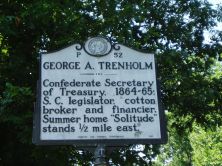
Confederate Secretary of Treasury, 1864-65; S.C. legislator, cotton broker and financier. Summer home "Solitude" stood 1/2 mile east.Plaque via North Carolina Highway Historical Marker...
- ncmarkers
- north carolina
SULPHUR SPRINGS

Health & social resort during the nineteenth century; patronized by low-country planters. Springs are 600 yds. S.Plaque via North Carolina Highway Historical Marker Program, and is used with their...
- ncmarkers
- north carolina
WILLIAM MOORE

Captain of militia force which marched against the Cherokee in Nov., 1776. A fort which he built stood near here. His home was 200 yds. E.Plaque via North Carolina Highway Historical...
- ncmarkers
- north carolina
STONEMAN'S RAID

Southern troops turned back Stoneman's U.S. cavalry, raiding through western North Carolina, at Swannanoa Gap, near here, April 20, 1865.Plaque via North Carolina Highway Historical...
- ncmarkers
- north carolina
UNIVERSITY OF N.C. AT ASHEVILLE

Established 1927; became Asheville-Biltmore College 1936. Moved here in 1961. A campus of The University of North Carolina, 1969.Plaque via North Carolina Highway Historical Marker Program, and is...
- ncmarkers
- north carolina
CONFEDERATE ARMORY

Manufactured Enfield-type rifles. In 1863 plant moved to Columbia, S.C. Building was located 1/4 mi. SE. Burned in 1865.Plaque via North Carolina Highway Historical Marker Program, and is...
- ncmarkers
- north carolina
N.C. EDUCATION ASSOCIATION

Organized in 1884 as N.C. Teachers Assembly in the White Sulphur Springs Hotel. Building was one mile northwest.Plaque via North Carolina Highway Historical Marker Program, and is used with...
- ncmarkers
- north carolina
FORESTRY SCHOOL
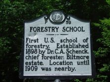
First U.S. school of forestry. Established 1898 by Dr. C. A. Schenck, chief forester, Biltmore estate. Location until 1909 was nearby.Plaque via North Carolina Highway Historical Marker...
- ncmarkers
- north carolina
EDGAR W. ('BILL') NYE 1850-1896

Humorist and journalist. Retired to N.C., 1891. Lived at "Buck Shoals," 3 1/2 mi. W. His grave is one mile north.Plaque via North Carolina Highway Historical Marker Program, and is used with...
- ncmarkers
- north carolina
SHERRILL'S INN

Established in 1834 to serve travelers crossing Hickory Nut Gap. In continuous service until 1909. House stands 300 yards south.Plaque via North Carolina Highway Historical Marker Program, and...
- ncmarkers
- north carolina
WEAVER COLLEGE
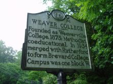
Founded as Weaverville College, 1873; Methodist, coeducational. In 1934 merged with Rutherford to form Brevard College. Campus was one block W.Plaque via North Carolina Highway Historical Marker...
- ncmarkers
- north carolina
ASHEVILLE NORMAL SCHOOL

Presbyterian. Opened 1887 as Home Industrial School. Teacher's College 1892-1944. Stood nearby.Plaque via North Carolina Highway Historical Marker Program, and is used with their permission. Full...
- ncmarkers
- north carolina