
JOHN W. THOMAS 1800-1871

Founder of Thomasville. As legislator led fight for N.C. Railroad; friend of education. His home, Cedar Lodge, was nearby.Plaque via North Carolina Highway Historical Marker Program, and is...
- ncmarkers
- north carolina
SAMARCAND

State juvenile facility. Est. in 1918 to provide girls with educational and vocational training. Campus is 3 mi. south.Plaque via North Carolina Highway Historical Marker Program, and is used with...
- ncmarkers
- north carolina
EDMUND DEBERRY 1787-1859

Member of Congress & State Senator. Planter and promoter of mining & manufacturing. Home here, grave 4/5 mi. west.Plaque via North Carolina Highway Historical Marker Program, and is used with...
- ncmarkers
- north carolina
JOHN H. MILLS

First head of Oxford Orphanage (1873-1884) and Thomasville Baptist Orphanage (Mills Home), president Oxford Female College. Grave 100 yds. S.Plaque via North Carolina Highway Historical Marker...
- ncmarkers
- north carolina
JOHN COLTRANE 1926-1967

Jazz saxophonist and composer; influential stylist. Work spanned bebop to avant garde. Born one block S.W.Plaque via North Carolina Highway Historical Marker Program, and is used with...
- ncmarkers
- north carolina
JAMES BOYD 1888-1944

Author of Drums (1925), Marching On (1927), and other historical novels. Home, "Weymouth," now an arts center, 3/10 mi. E. Author of "Drums" and "Marching On" & other historical novels. His...
- ncmarkers
- north carolina
TRINITY COLLEGE
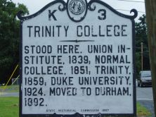
Stood here. Union Institute, 1839; Normal College, 1851; Trinity, 1859; Duke University, 1924. Moved to Durham, 1892.Plaque via North Carolina Highway Historical Marker Program, and is used with...
- ncmarkers
- north carolina
CAROLINA FEMALE COLLEGE, 1850-67

Established by local planters, later operated by Methodist Church. Building was 150 yds. W.Plaque via North Carolina Highway Historical Marker Program, and is used with their permission. Full page...
- ncmarkers
- north carolina
HENRY WILLIAM HARRINGTON

Brigadier general of militia, 1776-81, State senator, a commissioner to locate State capital. Grave is five miles S.Plaque via North Carolina Highway Historical Marker Program, and is used with...
- ncmarkers
- north carolina
PLANK ROAD
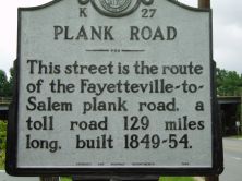
This street is the route of the Fayetteville-to- Salem plank road, a toll road 129 miles long, built 1849-54.Plaque via North Carolina Highway Historical Marker Program, and is used with...
- ncmarkers
- north carolina
PLANK ROAD
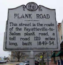
This street is the route of the Fayetteville-to- Salem plank road, a toll road 129 miles long, built 1849-54.Plaque via North Carolina Highway Historical Marker Program, and is used with...
- ncmarkers
- north carolina
PLANK ROAD

The route of the old Fayetteville-to-Salem plank road, a toll road 129 miles long, built 1849-54, crosses the highway near this point.Plaque via North Carolina Highway Historical Marker...
- ncmarkers
- north carolina
YADKIN COLLEGE

A Methodist Protestant institution. Opened in 1856, made co-educational in 1878, closed in 1924. Building stands 1 mi. N.Plaque via North Carolina Highway Historical Marker Program, and is...
- ncmarkers
- north carolina
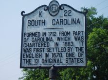
NORTH CAROLINA-SOUTH CAROLINA

NORTH CAROLINA / Colonized, 1585-87, by first English settlers in America; permanently settled c. 1650; first to vote readiness for independence, Apr. 12, 1776 b/w SOUTH CAROLINA / Formed in...
- ncmarkers
- north carolina
NORTH CAROLINA-SOUTH CAROLINA
NORTH CAROLINA / Colonized, 1585-87, by first English settlers in America; permanently settled c. 1650; first to vote readiness for independence, Apr. 12, 1776 b/w SOUTH CAROLINA / Formed in...
- ncmarkers
- north carolina
TRADING PATH

Colonial trading route, dating from 17th century, from Petersburg, Virginia, to Catawba and Waxhaw Indians in Carolina, passed nearby.Plaque via North Carolina Highway Historical Marker...
- ncmarkers
- north carolina
TRADING PATH

Colonial trading route, dating from 17th century, from Petersburg, Virginia, to Catawba and Waxhaw Indians in Carolina, passed nearby.Plaque via North Carolina Highway Historical Marker...
- ncmarkers
- north carolina
JONATHAN WORTH

Governor, 1865-1868. State Treasurer, 1862-1865. Home stood one block south.Plaque via North Carolina Highway Historical Marker Program, and is used with their permission. Full page here (NC Marker ID K2)
- ncmarkers
- north carolina
TRADING PATH

Colonial trading route, dating from 17th century, from Petersburg, Virginia, to Catawba and Waxhaw Indians in Carolina, passed nearby.Plaque via North Carolina Highway Historical Marker...
- ncmarkers
- north carolina
TRADING PATH

Colonial trading route, dating from 17th century, from Petersburg, Virginia, to the Catawba and Waxhaw Indians in Carolina, passed nearby.Plaque via North Carolina Highway Historical...
- ncmarkers
- north carolina