

ROBERT STRANGE

U.S. Senator, 1836-40; author of "Eoneguski, or Cherokee Chief," first novel about North Carolina (1839). Home and grave are 350 yds. east.Plaque via North Carolina Highway Historical...
- ncmarkers
- north carolina
UNION HEADQUARTERS

Maj. Gen. H. W. Slocum, commanding Sherman's Left Wing, had headquarters in this field, March 19-21, 1865.Plaque via North Carolina Highway Historical Marker Program, and is used with their...
- ncmarkers
- north carolina
FEDERAL ARTILLERY

Union batteries (26 guns) formed a line here, March 19. These guns covered retreating Federals during the Confederate charges and finally halted the advance of the Confederate Right...
- ncmarkers
- north carolina
LAFAYETTE

On March 4-5, 1825, was guest of Fayetteville (named for him 1783), staying at home of Duncan McRae, on site of present courthouse.Plaque via North Carolina Highway Historical Marker Program, and...
- ncmarkers
- north carolina
FLORAL COLLEGE

One of earliest colleges for women in the South, 1841-78. Centre Presbyterian Church, formerly the college chapel, is 150 yards north.Plaque via North Carolina Highway Historical Marker...
- ncmarkers
- north carolina
SHERMAN'S MARCH

As Sherman's army moved north from Georgia on its path of destruction, one part entered North Carolina near here, March 4-7, 1865.Plaque via North Carolina Highway Historical Marker Program, and...
- ncmarkers
- north carolina
SHERMAN'S MARCH

As Sherman's army moved north from Georgia, several units passed through Laurel Hill and camped in this vicinity, March 8-9, 1865.Plaque via North Carolina Highway Historical Marker Program, and...
- ncmarkers
- north carolina
MacPHERSON CHURCH

Presbyterian. Founded by early Scottish settlers. Graves of Alexander MacPherson and T. H. Holmes, a Confederate general, 1 1/2 miles N.Plaque via North Carolina Highway Historical Marker...
- ncmarkers
- north carolina
OLD TOWN HALL

Built on site of the "State House," burned 1831, where the North Carolina Convention of 1789 ratified the Federal Constitution.Plaque via North Carolina Highway Historical Marker Program, and...
- ncmarkers
- north carolina
FLORA MacDONALD COLLEGE

Presbyterian. Founded in 1896. Closed 1961. Merged to create St. Andrews College. Was located 1 mi. east.Plaque via North Carolina Highway Historical Marker Program, and is used with their...
- ncmarkers
- north carolina
SHERMAN'S MARCH
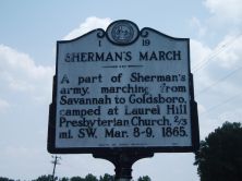
A part of Sherman's army, marching from Savannah to Goldsboro, camped at Laurel Hill Presbyterian Church, 2/3 mi. SW, Mar. 8-9, 1865.Plaque via North Carolina Highway Historical Marker...
- ncmarkers
- north carolina
U.S. ARSENAL

Authorized by Congress, 1836. Taken over by Confederacy, 1861. Destroyed March 1865, by Sherman. Ruins stand 2 blocks S.W.Plaque via North Carolina Highway Historical Marker Program, and is used...
- ncmarkers
- north carolina
ANGUS W. McLEAN 1870-1935
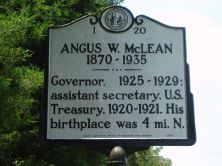
Governor, 1925-1929, assistant secretary, U.S. Treasury, 1920-1921. His birthplace was 4 mi. N.Plaque via North Carolina Highway Historical Marker Program, and is used with their permission. Full...
- ncmarkers
- north carolina
PLANK ROADS
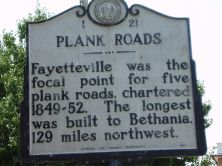
Fayetteville was the focal point for five plank roads, chartered 1849-52. The longest was built to Bethania, 129 miles northwest.Plaque via North Carolina Highway Historical Marker Program, and...
- ncmarkers
- north carolina
NORTH CAROLINA-SOUTH CAROLINA

NORTH CAROLINA / Colonized, 1585-87, by first English settlers in America; permanently settled c. 1650; first to vote readiness for independence, Apr. 12, 1776 b/w SOUTH CAROLINA / Formed in...
- ncmarkers
- north carolina
NORTH CAROLINA-SOUTH CAROLINA
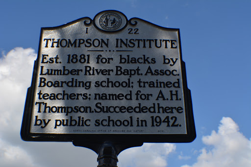
Est. 1881 for blacks by Lumber River Bapt. Assoc. Boarding school; trained teachers; named for A.H. Thompson. Succeeded here by public school in 1942.Plaque via North Carolina Highway...
- ncmarkers
- north carolina
SHERMAN'S MARCH

Sherman's army, on its march from Savannah, entered Goldsboro, its chief North Carolina objective, Mar. 21, 1865.Plaque via North Carolina Highway Historical Marker Program, and is used with their...
- ncmarkers
- north carolina
FORT BRAGG

Established 1918 as U.S. field artillery training center. Named for N.C. native Braxton Bragg, Lt. Col., USA; Gen., CSA.Plaque via North Carolina Highway Historical Marker Program, and is...
- ncmarkers
- north carolina
BATTLE OF ELIZABETHTOWN
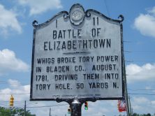
Whigs broke Tory power in Bladen Co., August, 1781, driving them into Tory Hole, 50 yards N.Plaque via North Carolina Highway Historical Marker Program, and is used with their permission. Full...
- ncmarkers
- north carolina
CROSS CREEK
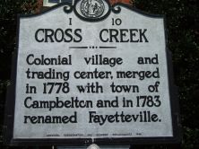
Colonial village and trading center, merged in 1778 with town of Campbelton and in 1783 renamed Fayetteville.Plaque via North Carolina Highway Historical Marker Program, and is used with...
- ncmarkers
- north carolina