

SPRUCE PINE MINING DISTRICT

Mica, feldspar, quartz deposits found in region 25 mi. long, 10 mi. wide. Commercial production of mica emerged 1850s.Plaque via North Carolina Highway Historical Marker Program, and is used with...
- ncmarkers
- north carolina
CROSSNORE SCHOOL

Founded by Mary Martin Sloop, physician, 1913, to serve region's youth. Weaving Room, est. 1920, boosted revival of handicrafts. Campus 1/2 mi. W.Plaque via North Carolina Highway...
- ncmarkers
- north carolina
LEES-McRAE COLLEGE
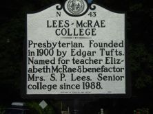
Presbyterian. Founded in 1900 by Edgar Tufts. Named for teacher Elizabeth McRae & benefactor Mrs. S. P. Lees. Senior college since 1988.Plaque via North Carolina Highway Historical Marker Program,...
- ncmarkers
- north carolina
EMILY PRUDDEN 1832-1917
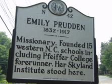
Missionary. Founded 15 western N.C. schools including Pfeiffer College forerunner. Her Skyland Institute stood here.Plaque via North Carolina Highway Historical Marker Program, and is used with...
- ncmarkers
- north carolina
CANE CREEK

Prelude to the Battle of Kings Mountain. Site of a skirmish on Sept. 12, 1780, between Loyalists and "Overmountain Men."Plaque via North Carolina Highway Historical Marker Program, and is...
- ncmarkers
- north carolina
PLEASANT GARDENS

Home of Joseph McDowell (1758-1795), soldier and physician. Officer at the Battle of Kings Mountain.Plaque via North Carolina Highway Historical Marker Program, and is used with their permission....
- ncmarkers
- north carolina
BROUGHTON HOSPITAL

State hospital for care of mentally ill; opened 1883. Named in 1959 for J. Melville Broughton, governor, 1941-1945.Plaque via North Carolina Highway Historical Marker Program, and is used with...
- ncmarkers
- north carolina
ELISHA MITCHELL 1793-1857

Scientist and professor. Died in attempt to prove this mountain highest in eastern U.S. Grave is at the summit, 285 yds. S.Plaque via North Carolina Highway Historical Marker Program, and is...
- ncmarkers
- north carolina
ANDREWS GEYSER

Built ca. 1885 to mark railroad gateway to the Blue Ridge Mts. Restored in 1911 & 1975. Named for A. B. Andrews of Raleigh. Located 2.1 miles north.Plaque via North Carolina Highway...
- ncmarkers
- north carolina
SHEPHERD M. DUGGER

Author of The Balsam Groves of the Grandfather Mountain, 1892; educator and humorist. Grave one block South.Plaque via North Carolina Highway Historical Marker Program, and is used with...
- ncmarkers
- north carolina
CARSON HOUSE
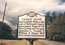
Served 1843-1845 as the seat of McDowell County government. Home of Col. John Carson and his sons, Jonathan L., Samuel P., William, & Joseph McD. Now a historical museum.Plaque via North...
- ncmarkers
- north carolina
BURKE COURTHOUSE

Built of local cut stone, ca. 1835, by James Binnie. August terms of State Supreme Court held here, 1847-61. Raided by Union force 1865. Remodeled 1901.Plaque via North Carolina Highway Historical...
- ncmarkers
- north carolina
STONEMAN'S RAID

On raid through western North Carolina Federal forces under Gen. George Stoneman erected a palisaded fort here in April 1865.Plaque via North Carolina Highway Historical Marker Program, and...
- ncmarkers
- north carolina
SWANNANOA GAP

Used by Indians and pioneers in crossing Blue Ridge. General Rutherford's expedition against Cherokee passed here, September, 1776.Plaque via North Carolina Highway Historical Marker Program, and...
- ncmarkers
- north carolina
FRONTIER FORT

Early outpost against Indians. Used by Gen. Rutherford in expedition against Cherokee, Sept., 1776. Stood nearby and gave name to this town.Plaque via North Carolina Highway Historical Marker...
- ncmarkers
- north carolina