CONFEDERATE PRISON
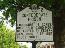
Enclosure, 16 acres. Once held 10,000 men. Destroyed by Federals, 1865. Site one block south.
Plaque via North Carolina Highway Historical Marker Program, and is used with their permission. Full page here (NC Marker ID L2)
Enclosure, 16 acres. Once held 10,000 men. Destroyed by Federals, 1865. Site one block south.
Plaque via North Carolina Highway Historical Marker Program, and is used with their permission. Full page here (NC Marker ID L2)