McPHAUL'S MILL
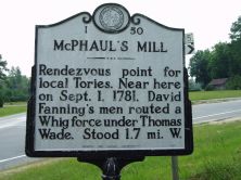
Rendezvous point for local Tories. Near here on Sept. 1, 1781, David Fanning's men routed a Whig force under Thomas Wade. Stood 1.7 mi. W.
Plaque via North Carolina Highway Historical Marker Program, and is used with their permission. Full page here (NC Marker ID I50)