Read the Plaque is finding your location, this can take a minute.
Please authorize your browser to share your location before closing this popup.
Newer versions of Chrome have disabled geolocation from non-https sources.
Try our https server which supports geolocation, and can run the the Nearby and Near Me buttons.
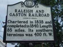
Chartered in 1835 and completed in 1840. Length 85 miles. Its southern terminus was 400 ft. W.
Plaque via North Carolina Highway Historical Marker Program, and is used with their permission. Full page here (NC Marker ID H23)
Nearby Plaques On Google Maps