The Founding of Cobourg
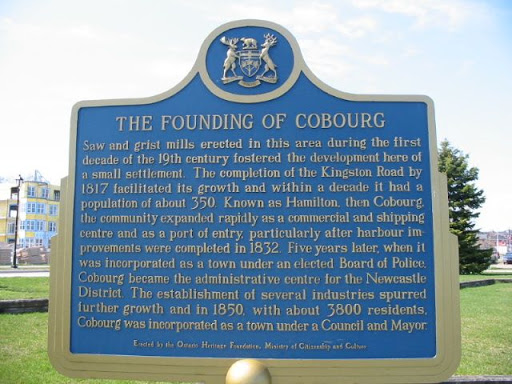
Saw and grist mills erected in this area during the first decade of the 19th century fostered the development here of a small settlement. The completion of the Kingston Road by 1817 facilitated its growth and within a decade it had a population of about 350. Known as Hamilton, then Cobourg, the community expanded rapidly as a commercial and shipping centre and as a port of entry, particularly after harbour improvements were completed in 1832. Five years later, when it was incorporated as a town under an elected Board of Police, Cobourg became the administrative centre for the Newcastle District. The establishment of several industries spurred further growth and in 1850, with about 3800 residents, Cobourg was incorporated as a town under a Council and Mayor.
Plaque via Alan L. Brown's site Ontario Plaques. Full page here.