
SALUDA GRADE

The steepest, standard gauge, mainline railway grade in the U.S. Opened in 1878; three mi. long. Crests here.Plaque via North Carolina Highway Historical Marker Program, and is used with...
- ncmarkers
- north carolina
CHIMNEY ROCK

Granite monolith. Site acquired by Lucius Morse in 1902. Developed into tourist attraction. State park, 2007. One mi. S.Plaque via North Carolina Highway Historical Marker Program, and is...
- ncmarkers
- north carolina
MOUNT HARMONY UNITED METHODIST CHURCH
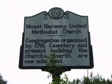
Congregation organized by 1791. Cemetery and present building, the church's fourth, are one mile west.Plaque via North Carolina Highway Historical Marker Program, and is used with...
- ncmarkers
- north carolina
STUART W. CRAMER 1868-1940

Engineer and inventor. Pioneered advances in textile mill air conditioning. Home 3 mi. SW.Plaque via North Carolina Highway Historical Marker Program, and is used with their permission. Full page...
- ncmarkers
- north carolina
TRYON MOUNTAIN

Landmark on Cherokee boundary, negotiated by Gov. William Tryon and Cherokee chiefs, 1767. Elevation 3,231 feet.Plaque via North Carolina Highway Historical Marker Program, and is used with...
- ncmarkers
- north carolina
NORTH CAROLINA ORTHOPEDIC HOSPITAL

State institution for crippled children, 1921-1979. R. B. Babington was its first president; O. L. Miller, founding surgeon.Plaque via North Carolina Highway Historical Marker Program, and is used...
- ncmarkers
- north carolina
MICHAEL HOKE 1874-1944

Pioneer orthopedic surgeon; founded hospitals for crippled children; chief surgeon of Warm Springs (Ga.) Foundation. Birthplace 80 yds. east.Plaque via North Carolina Highway Historical...
- ncmarkers
- north carolina
STEPHEN D. RAMSEUR

West Point graduate. A Confederate major general at 27; mortally wounded, Cedar Creek, Va. Grave 2 blocks N.Plaque via North Carolina Highway Historical Marker Program, and is used with...
- ncmarkers
- north carolina
IRON WORKS

Many iron mines and forges were operated within a radius of ten miles of this point between 1790 and 1880.Plaque via North Carolina Highway Historical Marker Program, and is used with their...
- ncmarkers
- north carolina
EARLY TRANS-CATAWBA HISTORY
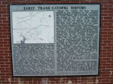
Plaque via North Carolina Highway Historical Marker Program, and is used with their permission. Full page here (NC Marker ID OO1)
- ncmarkers
- north carolina
BUNKER HILL COVERED BRIDGE
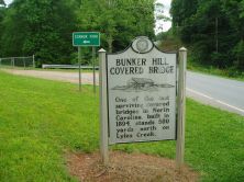
One of the last surviving covered bridges in North Carolina, built in 1894, stands 500 yards north on Lyles Creek.Plaque via North Carolina Highway Historical Marker Program, and is used with...
- ncmarkers
- north carolina
CALVARY CHURCH EPISCOPAL

Built 1859. Grave of "Bill" Nye. Memorials to many famous southerners.Plaque via North Carolina Highway Historical Marker Program, and is used with their permission. Full page here (NC Marker ID P1)
- ncmarkers
- north carolina
MARTIN'S SURRENDER

Gen. James G. Martin surrendered District of Western North Carolina, the last Confederate forces in the state, May 7, 1865, in Waynesville.Plaque via North Carolina Highway Historical Marker...
- ncmarkers
- north carolina
NORTH CAROLINA-SOUTH CAROLINA

NORTH CAROLINA / Colonized, 1585-87, by first English settlers in America; permanently settled c. 1650; first to vote readiness for independence, Apr. 12, 1776 b/w SOUTH CAROLINA / Formed in...
- ncmarkers
- north carolina
BINGHAM SCHOOL

A boys' military school, operated by Robert Bingham, 1891-1928. Moved from Mebane. Campus was 1 mile S.W.Plaque via North Carolina Highway Historical Marker Program, and is used with...
- ncmarkers
- north carolina
THOMAS WOLFE
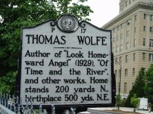
Author of "Look Homeward Angel" (1929), "Of Time and the River," and other works. Home stands 200 yards N., birthplace 500 yds. N.E.Plaque via North Carolina Highway Historical Marker Program, and...
- ncmarkers
- north carolina
NEWTON ACADEMY

Established before 1793 as Union Hill Academy. Named for Rev. George Newton. Present Newton Academy School is 4th building on this site.Plaque via North Carolina Highway Historical Marker Program,...
- ncmarkers
- north carolina
MORNING STAR CHURCH
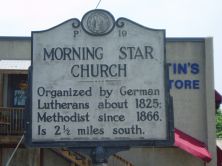
Organized by German Lutherans about 1825; Methodist since 1866. Is 2 1/2 miles south.Plaque via North Carolina Highway Historical Marker Program, and is used with their permission. Full page here...
- ncmarkers
- north carolina
ZEBULON B. VANCE 1830-1894
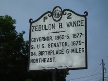
Civil War governor. He led state, 1862-65, and 1877-79; U.S. Senator, 1879-94. Colonel, 26th N.C. Regiment, 1861-62. Birthplace 6 miles N.E.Plaque via North Carolina Highway Historical...
- ncmarkers
- north carolina
FRENCH BROAD BAPTIST CHURCH

Organized before 1792. Present building is here. First building stood 1 mile south.Plaque via North Carolina Highway Historical Marker Program, and is used with their permission. Full page here...
- ncmarkers
- north carolina