
PLANK ROAD
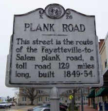
This street is the route of the Fayetteville-to- Salem plank road, a toll road 129 miles long, built 1849-54.Plaque via North Carolina Highway Historical Marker Program, and is used with...
- ncmarkers
- north carolina
PLANK ROAD

The route of the old Fayetteville-to-Salem plank road, a toll road 129 miles long, built 1849-54, crosses the highway near this point.Plaque via North Carolina Highway Historical Marker...
- ncmarkers
- north carolina
YADKIN COLLEGE

A Methodist Protestant institution. Opened in 1856, made co-educational in 1878, closed in 1924. Building stands 1 mi. N.Plaque via North Carolina Highway Historical Marker Program, and is...
- ncmarkers
- north carolina
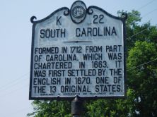
NORTH CAROLINA-SOUTH CAROLINA

NORTH CAROLINA / Colonized, 1585-87, by first English settlers in America; permanently settled c. 1650; first to vote readiness for independence, Apr. 12, 1776 b/w SOUTH CAROLINA / Formed in...
- ncmarkers
- north carolina
NORTH CAROLINA-SOUTH CAROLINA
NORTH CAROLINA / Colonized, 1585-87, by first English settlers in America; permanently settled c. 1650; first to vote readiness for independence, Apr. 12, 1776 b/w SOUTH CAROLINA / Formed in...
- ncmarkers
- north carolina
TRADING PATH

Colonial trading route, dating from 17th century, from Petersburg, Virginia, to Catawba and Waxhaw Indians in Carolina, passed nearby.Plaque via North Carolina Highway Historical Marker...
- ncmarkers
- north carolina
TRADING PATH

Colonial trading route, dating from 17th century, from Petersburg, Virginia, to Catawba and Waxhaw Indians in Carolina, passed nearby.Plaque via North Carolina Highway Historical Marker...
- ncmarkers
- north carolina
JONATHAN WORTH

Governor, 1865-1868. State Treasurer, 1862-1865. Home stood one block south.Plaque via North Carolina Highway Historical Marker Program, and is used with their permission. Full page here (NC Marker ID K2)
- ncmarkers
- north carolina
TRADING PATH

Colonial trading route, dating from 17th century, from Petersburg, Virginia, to Catawba and Waxhaw Indians in Carolina, passed nearby.Plaque via North Carolina Highway Historical Marker...
- ncmarkers
- north carolina
TRADING PATH

Colonial trading route, dating from 17th century, from Petersburg, Virginia, to the Catawba and Waxhaw Indians in Carolina, passed nearby.Plaque via North Carolina Highway Historical...
- ncmarkers
- north carolina
SAMUEL SPENCER

Jurist & Antifederalist leader. Member of court which in 1787 issued the first reported precedent for judicial review. His home stood 3 miles N.E.Plaque via North Carolina Highway...
- ncmarkers
- north carolina
JEFFERSON DAVIS

President Davis, fleeing southward after Lee's surrender, with members of his cabinet spent the night of Apr. 16, 1865, in a pine grove nearby.Plaque via North Carolina Highway Historical Marker...
- ncmarkers
- north carolina
STONEMAN'S RAID

Southern troops turned back Stoneman's U.S. cavalry, raiding through western North Carolina, at the Yadkin River bridge, April 12, 1865.Plaque via North Carolina Highway Historical Marker Program,...
- ncmarkers
- north carolina
SHERMAN'S MARCH

Kilpatrick's Cavalry, a part of Sherman's army marching from Savannah to Goldsboro, passed through Wadesboro, March 3-5, 1865.Plaque via North Carolina Highway Historical Marker Program, and is...
- ncmarkers
- north carolina
SHERMAN'S MARCH

As Sherman's army moved north from Georgia on its path of destruction, one part entered North Carolina near here, March 4-7, 1865.Plaque via North Carolina Highway Historical Marker Program, and...
- ncmarkers
- north carolina
SHERMAN'S MARCH
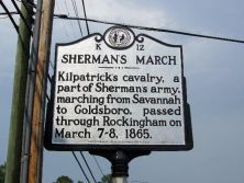
Kilpatrick's Cavalry, a part of Sherman's Army, marching from Savannah to Goldsboro, passed through Rockingham on March 7-8, 1865.Plaque via North Carolina Highway Historical Marker Program, and...
- ncmarkers
- north carolina
LEONIDAS L. POLK 1837-1892

President of National Farmers' Alliance, 1889-1892; began Progressive Farmer, 1886; a founder of NCSU and Meredith College. Was born here.Plaque via North Carolina Highway Historical Marker...
- ncmarkers
- north carolina
COX'S MILL

Headquarters, 1781-82, of David Fanning, Tory leader. Owner, Harmon Cox, led area Regulators. Mill was 1/2 mile south.Plaque via North Carolina Highway Historical Marker Program, and is used with...
- ncmarkers
- north carolina
WALTER HINES PAGE

Ambassador to Great Britain during World War, journalist, editor, publisher. Tomb one mile east.Plaque via North Carolina Highway Historical Marker Program, and is used with their permission. Full...
- ncmarkers
- north carolina
THE PRESBYTERIAN CHURCH IN NORTH CAROLINA
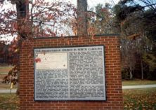
Plaque via North Carolina Highway Historical Marker Program, and is used with their permission. Full page here (NC Marker ID JJ1)
- ncmarkers
- north carolina