
GRIFFITH RUTHERFORD ca. 1721-1805
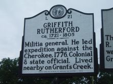
Militia general. He led expedition against the Cherokee, 1776. Colonial & state official. Lived nearby on Grant's Creek.Plaque via North Carolina Highway Historical Marker Program, and is...
- ncmarkers
- north carolina
SAM'L E. McCORKLE

Presbyterian preacher and educator. The site of his famous academy, Zion Parnassus (about 1794 to 1798) is 3/4 of a mile north.Plaque via North Carolina Highway Historical Marker Program, and...
- ncmarkers
- north carolina
CONFEDERATE PRISON
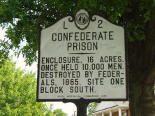
Enclosure, 16 acres. Once held 10,000 men. Destroyed by Federals, 1865. Site one block south.Plaque via North Carolina Highway Historical Marker Program, and is used with their permission. Full...
- ncmarkers
- north carolina
NATHANAEL GREENE 1742-1786

Replaced Horatio Gates as leader of American army opposing Lord Cornwallis. He assumed command in Charlotte, Dec. 3, 1780.Plaque via North Carolina Highway Historical Marker Program, and is...
- ncmarkers
- north carolina
BATTLE OF CHARLOTTE

Cornwallis's army captured Charlotte after a fight here with Davie's troops, Sept. 26, 1780.Plaque via North Carolina Highway Historical Marker Program, and is used with their permission....
- ncmarkers
- north carolina
RURAL FREE DELIVERY
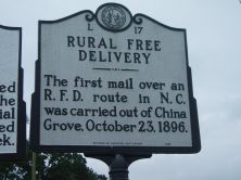
The first mail over an R.F.D. route in N.C. was carried out of China Grove, October 23, 1896.Plaque via North Carolina Highway Historical Marker Program, and is used with their permission. Full...
- ncmarkers
- north carolina
COLSON'S SUPPLY DEPOT

Fortified Revolutionary depot built 1781 to protect supplies and arms of Gen. Nathanael Greene. Trenches are 4 1/2 miles W.Plaque via North Carolina Highway Historical Marker Program, and is used...
- ncmarkers
- north carolina
CARTLEDGE CREEK BAPTIST CHURCH
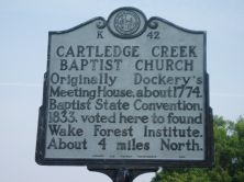
Originally Dockery's Meeting House, about 1774. Baptist State Convention, 1833, voted here to found Wake Forest Institute. About 4 miles North.Plaque via North Carolina Highway Historical Marker...
- ncmarkers
- north carolina
JOHN STEELE

Congressman, 1789-93, Comptroller of the United States Treasury, Federalist party leader. Home stands 2 blocks east.Plaque via North Carolina Highway Historical Marker Program, and is used with...
- ncmarkers
- north carolina
OLD DAVIDSON COUNTY COURTHOUSE

Completed 1858. Interior was burned, 1865, rebuilt ca. 1867. Fine example of Classical Revival style.Plaque via North Carolina Highway Historical Marker Program, and is used with their...
- ncmarkers
- north carolina
HAMLET STATION
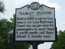
Built in 1900 to serve Seaboard Air Line Railroad. Depot was major stop for passengers on east-west & north-south rail lines. About 2 blocks east.Plaque via North Carolina Highway Historical...
- ncmarkers
- north carolina
ZION UNITED METHODIST CHURCH
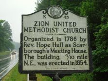
Organized in 1786 by Rev. Hope Hull as Scarborough's Meeting House. The building, 4/10 mile N.E., was erected in 1854.Plaque via North Carolina Highway Historical Marker Program, and is used with...
- ncmarkers
- north carolina
'CHRISTIAN REID' 1846-1920

Pen name of Frances Fisher Tiernan, author of Land of the Sky and other novels. Her grave is 200 yards N.W.Plaque via North Carolina Highway Historical Marker Program, and is used with...
- ncmarkers
- north carolina
JOHN MACRAE

Gaelic poet. Emigrated from Scotland in 1774. Loyalist during the Revolution. His home stood 2 1/2 miles south.Plaque via North Carolina Highway Historical Marker Program, and is used with...
- ncmarkers
- north carolina
ALFRED DOCKERY 1797-1875

U.S. Congressman; state legislator for 10 years. A founder of the state Republican party, 1867. Home is 6 mi. northwest.Plaque via North Carolina Highway Historical Marker Program, and is...
- ncmarkers
- north carolina
JOHN BETHUNE

Early pastor for Scots in N.C.; chaplain for Loyalists at Battle of Moores Creek Bridge, 1776. First Presbyterian minister in Ontario. Lived 4 mi. S.Plaque via North Carolina Highway...
- ncmarkers
- north carolina
PILGRIM CHURCH

Established ca. 1757 as German Reformed. Known early as Leonard's Church. Fourth building to occupy site stands 3/8 mi. N.W.Plaque via North Carolina Highway Historical Marker Program, and is used...
- ncmarkers
- north carolina
SANDY CREEK BAPTIST CHURCH

Mother of Separate Baptist churches across the South. Founded by Shubal Stearns, 1755. His grave is two miles south.Plaque via North Carolina Highway Historical Marker Program, and is used with...
- ncmarkers
- north carolina
CAMERON MORRISON 1869-1953

Governor, 1921-1925; State legislator; U.S. Senator & Congressman; mayor of Rockingham. Birthplace was 6 mi. S.Plaque via North Carolina Highway Historical Marker Program, and is used with their...
- ncmarkers
- north carolina
ROCKY RIVER CHURCH
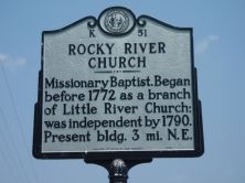
Missionary Baptist. Began before 1772 as a branch of Little River Church; was independent by 1790. Present bldg. 3 mi. N.E.Plaque via North Carolina Highway Historical Marker Program, and is...
- ncmarkers
- north carolina