

SAMUEL ASHE 1725-1813

Governor, 1795-1798; one of the first three state judges; president, Council of Safety, 1776. His grave is 3 miles east.Plaque via North Carolina Highway Historical Marker Program, and is...
- ncmarkers
- north carolina
OAKDALE CEMETERY

Est. in 1852. Includes graves of Confederate leaders, officers, and soldiers, & victims of yellow fever epidemic of 1862. Six blocks N.Plaque via North Carolina Highway Historical Marker Program,...
- ncmarkers
- north carolina
NICHOLAS N. NIXON 1800-1868

Planter. Developed peanut into profitable crop by scientific methods at his Porters Neck Plantation 2 miles east.Plaque via North Carolina Highway Historical Marker Program, and is used with...
- ncmarkers
- north carolina
CATHERINE KENNEDY HOME

For the elderly. Grew from Ladies Benevolent Society, founded, 1845. First home, 1879, stood four blocks east.Plaque via North Carolina Highway Historical Marker Program, and is used with...
- ncmarkers
- north carolina
BALD HEAD LIGHTHOUSE

Original lighthouse was erected in 1794. Present tower, "Old Baldy," built in 1817. Used until 1935. Stands 3 miles south.Plaque via North Carolina Highway Historical Marker Program, and is used...
- ncmarkers
- north carolina
GENERAL JOHN ASHE

Stamp Act patriot; Speaker of the House. Colonel under Tryon in "War of Regulation." Revolutionary General. Home stood 2 mi. east.Plaque via North Carolina Highway Historical Marker Program, and...
- ncmarkers
- north carolina
JOHNSON JONES HOOPER

Editor and humorist, creator of "Simon Suggs" and other characters of the Southern frontier. Born in this city, 1815.Plaque via North Carolina Highway Historical Marker Program, and is used with...
- ncmarkers
- north carolina
MAURICE MOORE

Leader in Tuscarora and S.C. Indian Wars. One of original Cape Fear settlers. Founded Brunswick, 1726. His plantation was 3 mi. SE.Plaque via North Carolina Highway Historical Marker Program, and...
- ncmarkers
- north carolina
FORT CASWELL

Seized by N.C. Militia three months before firing on Fort Sumter, Governor Ellis ordered its return to Federal authority; three mi. E.Plaque via North Carolina Highway Historical Marker Program,...
- ncmarkers
- north carolina
JOHN N. MAFFITT

Captain of Confederate cruiser "Florida" and ironclad "Albemarle." With U.S. Coast Survey, 1842-1858. Blockade-runner. Grave 14 blks. N.E.Plaque via North Carolina Highway Historical Marker...
- ncmarkers
- north carolina
BEERY'S SHIPYARD

Many Confederate naval vessels, including the ironclad "North Carolina," built here. Site lies across river on Eagles Island, 1/4 mile west.Plaque via North Carolina Highway Historical Marker...
- ncmarkers
- north carolina
MOORE'S CREEK BRIDGE

First battle of the Revolution in North Carolina, Feb. 27, 1776. Tories defeated. U.S. Military Park, 5 mi. S.W.Plaque via North Carolina Highway Historical Marker Program, and is used with...
- ncmarkers
- north carolina
ADAM EMPIE, D.D.

First chaplain of U.S. Military Academy, West Point, 1813-1817; president William and Mary College; rector St. James Church. Grave 3/4 mi. N.E.Plaque via North Carolina Highway Historical Marker...
- ncmarkers
- north carolina
WILLIAM S. ASHE
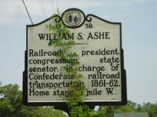
Railroad president, congressman, state senator. In charge of Confederate railroad transportation, 1861-62. Home stands 1 mile W.Plaque via North Carolina Highway Historical Marker Program, and...
- ncmarkers
- north carolina
ROSE GREENHOW
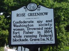
Confederate spy and Washington society woman. Drowned near Fort Fisher in 1864, while running Federal blockade. Grave 1 m. N.E.Plaque via North Carolina Highway Historical Marker Program, and...
- ncmarkers
- north carolina
JUDAH P. BENJAMIN
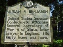
United States Senator, Confederate Attorney General, Secretary of War & of State, later lawyer in England. His early home was here.Plaque via North Carolina Highway Historical Marker Program, and...
- ncmarkers
- north carolina
ST. PHILIPS CHURCH

Anglican, built under act of 1751. Graves of Governors Arthur Dobbs and Benjamin Smith and U.S. Justice Alfred Moore. Ruins 2 mi. S.E.Plaque via North Carolina Highway Historical Marker...
- ncmarkers
- north carolina
BRUNSWICK

Founded c. 1725, long a principal port of N.C., site of Spanish attack, 1748, and of Stamp Act resistance, 1766. Later abandoned. Was 2 mi. S.E.Plaque via North Carolina Highway Historical Marker...
- ncmarkers
- north carolina
ORTON PLANTATION

House built c. 1725, subsequent additions. Home first of Roger Moore, later of Gov. Benjamin Smith, still later of James Sprunt. 3/4 mi. E.Plaque via North Carolina Highway Historical Marker...
- ncmarkers
- north carolina
SAMUEL SWANN

Speaker of assembly nearly 20 years, leader popular party, compiler first printed revisal of N.C. laws (1752). Home stood one mile south.Plaque via North Carolina Highway Historical...
- ncmarkers
- north carolina