
TRADING PATH
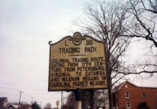
Colonial trading route dating from 17th century, from Petersburg, Virginia, to the Catawba and Waxhaw Indians in Carolina, passed nearby.Plaque via North Carolina Highway Historical...
- ncmarkers
- north carolina
CONFEDERATE CABINET
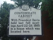
With President Davis held last full meetings April 22-26, 1865 in a house which was located here.Plaque via North Carolina Highway Historical Marker Program, and is used with their...
- ncmarkers
- north carolina
STONEMAN'S RAID

Stoneman's U.S. cavalry occupied the town of Salisbury, Apr. 12, 1865, and destroyed the Confederate warehouses, supplies, and prison.Plaque via North Carolina Highway Historical Marker Program,...
- ncmarkers
- north carolina
STONEMAN'S RAID

On their raid through western N. C., Gen. George Stoneman's U.S. cavalry fought a skirmish with Confederate troops near here, April 12, 1865.Plaque via North Carolina Highway Historical Marker...
- ncmarkers
- north carolina
LEE S. OVERMAN

United States Senator, 1903-30, a leading supporter of Wilson's war policies, Speaker of House of Representatives. His home is here.Plaque via North Carolina Highway Historical Marker Program, and...
- ncmarkers
- north carolina
KNOX HOME

Home of the Knox family since colonial days. James Knox, grandfather of President James Knox Polk, lived there. House stood 4 miles west.Plaque via North Carolina Highway Historical Marker...
- ncmarkers
- north carolina
CAMP GREENE

World War I training camp operated here on 6,000 acres, 1917-1919. Named for Revolutionary War Gen. Nat'l Greene.Plaque via North Carolina Highway Historical Marker Program, and is used with...
- ncmarkers
- north carolina
TRADING FORD
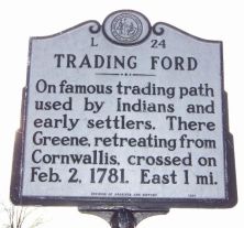
On famous trading path used by Indians and early settlers. There Greene, retreating from Cornwallis, crossed on Feb. 2, 1781. East 1 mi.Plaque via North Carolina Highway Historical Marker Program,...
- ncmarkers
- north carolina
WILLIAM LEE DAVIDSON

Whig general, was killed at Cowan's Ford, Feb. 1, 1781. Davidson College and Davidson County are named for him.Plaque via North Carolina Highway Historical Marker Program, and is used with...
- ncmarkers
- north carolina
BATTLE OF COWAN'S FORD

Cornwallis, pursuing Greene, crossed the Catawba, 7 mi. w., after sharp fight, Feb. 1, 1781.Plaque via North Carolina Highway Historical Marker Program, and is used with their permission....
- ncmarkers
- north carolina
GRIFFITH RUTHERFORD ca. 1721-1805
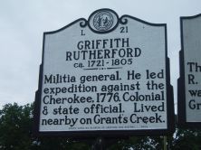
Militia general. He led expedition against the Cherokee, 1776. Colonial & state official. Lived nearby on Grant's Creek.Plaque via North Carolina Highway Historical Marker Program, and is...
- ncmarkers
- north carolina
SAM'L E. McCORKLE

Presbyterian preacher and educator. The site of his famous academy, Zion Parnassus (about 1794 to 1798) is 3/4 of a mile north.Plaque via North Carolina Highway Historical Marker Program, and...
- ncmarkers
- north carolina
CONFEDERATE PRISON
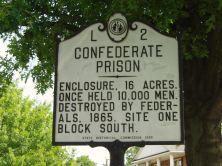
Enclosure, 16 acres. Once held 10,000 men. Destroyed by Federals, 1865. Site one block south.Plaque via North Carolina Highway Historical Marker Program, and is used with their permission. Full...
- ncmarkers
- north carolina
NATHANAEL GREENE 1742-1786

Replaced Horatio Gates as leader of American army opposing Lord Cornwallis. He assumed command in Charlotte, Dec. 3, 1780.Plaque via North Carolina Highway Historical Marker Program, and is...
- ncmarkers
- north carolina
BATTLE OF CHARLOTTE

Cornwallis's army captured Charlotte after a fight here with Davie's troops, Sept. 26, 1780.Plaque via North Carolina Highway Historical Marker Program, and is used with their permission....
- ncmarkers
- north carolina
RURAL FREE DELIVERY
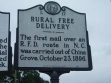
The first mail over an R.F.D. route in N.C. was carried out of China Grove, October 23, 1896.Plaque via North Carolina Highway Historical Marker Program, and is used with their permission. Full...
- ncmarkers
- north carolina
COLSON'S SUPPLY DEPOT

Fortified Revolutionary depot built 1781 to protect supplies and arms of Gen. Nathanael Greene. Trenches are 4 1/2 miles W.Plaque via North Carolina Highway Historical Marker Program, and is used...
- ncmarkers
- north carolina
CARTLEDGE CREEK BAPTIST CHURCH
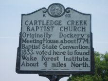
Originally Dockery's Meeting House, about 1774. Baptist State Convention, 1833, voted here to found Wake Forest Institute. About 4 miles North.Plaque via North Carolina Highway Historical Marker...
- ncmarkers
- north carolina
JOHN STEELE

Congressman, 1789-93, Comptroller of the United States Treasury, Federalist party leader. Home stands 2 blocks east.Plaque via North Carolina Highway Historical Marker Program, and is used with...
- ncmarkers
- north carolina
OLD DAVIDSON COUNTY COURTHOUSE

Completed 1858. Interior was burned, 1865, rebuilt ca. 1867. Fine example of Classical Revival style.Plaque via North Carolina Highway Historical Marker Program, and is used with their...
- ncmarkers
- north carolina