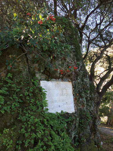

RICHMOND PEARSON 1852-1923

Congressman, 1895-1901; U.S. Minister to Persia, 1902-07, and to Greece and Montenegro, 1907-09. His home, "Richmond Hill," was 1/2 mile N.W.Plaque via North Carolina Highway Historical...
- ncmarkers
- north carolina
RUTHERFORD TRACE

The expedition led by Gen. Griffith Rutherford against the Cherokee, September, 1776, passed nearby on the banks of the Swannanoa River.Plaque via North Carolina Highway Historical Marker Program,...
- ncmarkers
- north carolina
RUTHERFORD TRACE

The expedition led by Gen. Griffith Rutherford against the Cherokee, Sept., 1776, passed nearby.Plaque via North Carolina Highway Historical Marker Program, and is used with their permission. Full...
- ncmarkers
- north carolina
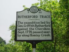
RUTHERFORD TRACE

The expedition led by Gen. Griffith Rutherford against the Cherokee, Sept., 1776, camped nearby along Hominy Creek.Plaque via North Carolina Highway Historical Marker Program, and is used with...
- ncmarkers
- north carolina
C. G. MEMMINGER

Secretary of the treasury of the Confederacy, from Charleston. Native of Germany. Summer home and grave nearby.Plaque via North Carolina Highway Historical Marker Program, and is used with...
- ncmarkers
- north carolina
RUTHERFORD TRACE
The expedition led by Gen. Griffith Rutherford against the Cherokee, Sept., 1776, passed nearby along Hominy Creek.Plaque via North Carolina Highway Historical Marker Program, and is used with...
- ncmarkers
- north carolina
RUTHERFORD TRACE

The expedition led by Gen. Griffith Rutherford against the Cherokee, Sept., 1776, passed here, through Pigeon Gap.Plaque via North Carolina Highway Historical Marker Program, and is used with...
- ncmarkers
- north carolina
RUTHERFORD TRACE

The expedition led by Gen. Griffith Rutherford against the Cherokee, Sept., 1776, passed here, through Balsam Gap.Plaque via North Carolina Highway Historical Marker Program, and is used with...
- ncmarkers
- north carolina
JUDSON COLLEGE

Baptist. Chartered in 1861 as Judson Female College; later coeducational. Operated 1882-1892 in building which stood three blocks S.W.Plaque via North Carolina Highway Historical Marker Program,...
- ncmarkers
- north carolina
KIFFIN Y. ROCKWELL
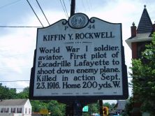
World War I soldier, aviator. First pilot of Escadrille Lafayette to shoot down enemy plane. Killed in action, Sept. 23, 1916. Home 200 yds. W.Plaque via North Carolina Highway Historical Marker...
- ncmarkers
- north carolina
FLAT ROCK

Landmark for Indians and the pioneer white settlers of this area, lies nearby. Town of Flat Rock named for this natural formation.Plaque via North Carolina Highway Historical Marker Program, and...
- ncmarkers
- north carolina
SWANNANOA TUNNEL

Longest (1,800 ft.) of 7 on railroad between Old Fort and Asheville. Constructed by convict labor, 1877-79. West entrance 300 yds. S.E.Plaque via North Carolina Highway Historical Marker...
- ncmarkers
- north carolina
ESTATOE PATH

Trading route between mountain settlements of the Cherokee and their town Estatoe, in what is now South Carolina, passed nearby.Plaque via North Carolina Highway Historical Marker Program, and...
- ncmarkers
- north carolina
ESTATOE PATH

Trading route between mountain settlements of the Cherokee and their town, Estatoe, in what is now South Carolina, passed nearby.Plaque via North Carolina Highway Historical Marker Program, and...
- ncmarkers
- north carolina
JOSEPH LANE

Territorial Governor of Oregon, 1848-50, Vice- Presidential candidate, 1860, U.S. Senator, major general in Mexican War. Born 3 miles east.Plaque via North Carolina Highway Historical...
- ncmarkers
- north carolina
DAVID L. SWAIN

Governor and political leader. President of the University of North Carolina, 1835-1868. Was born three miles E.Plaque via North Carolina Highway Historical Marker Program, and is used with...
- ncmarkers
- north carolina
'CATALOOCHEE TRAIL'

An old Indian path across mountains used by early settlers and in 1810 by Bishop Asbury. Trail passed nearby.Plaque via North Carolina Highway Historical Marker Program, and is used with...
- ncmarkers
- north carolina
'CATALOOCHEE TRAIL'

Indian path across the mountains used by early settlers and in 1810 by Bishop Francis Asbury. Trail passed nearby.Plaque via North Carolina Highway Historical Marker Program, and is used with...
- ncmarkers
- north carolina
GEORGE A. TRENHOLM
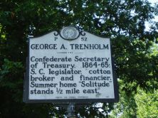
Confederate Secretary of Treasury, 1864-65; S.C. legislator, cotton broker and financier. Summer home "Solitude" stood 1/2 mile east.Plaque via North Carolina Highway Historical Marker...
- ncmarkers
- north carolina
SULPHUR SPRINGS

Health & social resort during the nineteenth century; patronized by low-country planters. Springs are 600 yds. S.Plaque via North Carolina Highway Historical Marker Program, and is used with their...
- ncmarkers
- north carolina