

SHAW UNIVERSITY

Founded 1865 by Baptist missionary Henry Martin Tupper. Chartered 1875; named for benefactor Elijah Shaw of Mass.Plaque via North Carolina Highway Historical Marker Program, and is used with their...
- ncmarkers
- north carolina
GENERAL GRANT
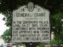
In the Governor's Palace April 24-27, 1865, Grant conferred with Sherman and approved new terms for surrender of Johnston's Confederate Army.Plaque via North Carolina Highway Historical...
- ncmarkers
- north carolina
OLD BREASTWORKS

Breastworks were thrown up around Raleigh, 1863, by order of Governor Vance, for protection against Federal raids. Remains are 1/3 mile W.Plaque via North Carolina Highway Historical Marker...
- ncmarkers
- north carolina
ISAAC HUNTER'S TAVERN

Stood nearby. State Capital located within 10 miles by order N.C. Convention, 1788.Plaque via North Carolina Highway Historical Marker Program, and is used with their permission. Full page...
- ncmarkers
- north carolina
FALL OF RALEIGH

Commissioners of North Carolina's capital met officers of Sherman's army near this spot, on April 13, 1865, and surrendered the city.Plaque via North Carolina Highway Historical Marker Program,...
- ncmarkers
- north carolina
SHERMAN'S MARCH

Moving on Goldsboro, Sherman's Army was temporarily checked by Hardee's Confederates, Mar. 16, 1865, in Battle of Averasboro, 3 1/2 mi. W.Plaque via North Carolina Highway Historical Marker...
- ncmarkers
- north carolina
LEONIDAS L. POLK 1837-1892

President of National Farmers' Alliance, 1889-1892; began Progressive Farmer, 1886; a founder of N.C.S.U. and Meredith College. House is here.Plaque via North Carolina Highway Historical Marker...
- ncmarkers
- north carolina
CAMP BRYAN GRIMES

Spanish-American War camp, 95 acres, named for the Confederate general, was located here. Only U.S. Army camp in the state, 1898.Plaque via North Carolina Highway Historical Marker Program, and...
- ncmarkers
- north carolina
NORTH CAROLINA STATE UNIVERSITY AT RALEIGH
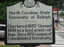
Chartered 1887. Opened 1889 as a land grant college. Since 1931 campus of Consolidated University.Plaque via North Carolina Highway Historical Marker Program, and is used with their permission....
- ncmarkers
- north carolina
WILCOX IRON WORKS

Important source of munitions during the American Revolution, operated occasionally since. Furnace was 100 yards southwest.Plaque via North Carolina Highway Historical Marker Program, and is...
- ncmarkers
- north carolina
RALEIGH AND GASTON RAILROAD
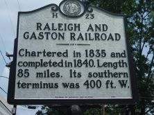
Chartered in 1835 and completed in 1840. Length 85 miles. Its southern terminus was 400 ft. W.Plaque via North Carolina Highway Historical Marker Program, and is used with their permission....
- ncmarkers
- north carolina
EXPERIMENTAL RAILROAD

Est. 1833. Horses hauled granite for the Capitol over a railroad from a quarry 1 1/4 miles S.E.Plaque via North Carolina Highway Historical Marker Program, and is used with their permission. Full...
- ncmarkers
- north carolina
WALTER HINES PAGE 1855-1918

Journalist, editor, and publisher. Ambassador to Great Britain, 1913-1918. His birthplace stood 400 yards north.Plaque via North Carolina Highway Historical Marker Program, and is used with...
- ncmarkers
- north carolina
JOEL LANE HOUSE
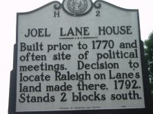
Built prior to 1770 and often site of political meetings. Decision to locate Raleigh on Lane's land made there, 1792. Stands 2 blocks south.Plaque via North Carolina Highway Historical Marker...
- ncmarkers
- north carolina
CHARLES D. McIVER 1860-1906

Educator and first president of what is now UNC- Greensboro, 1891-1906. Boyhood home is 200 yds. W.Plaque via North Carolina Highway Historical Marker Program, and is used with their...
- ncmarkers
- north carolina
RAMSEY'S MILL

Cornwallis, following the battle of Guilford Courthouse, spent several days building a bridge over Deep River, at point 300 yards N.W.Plaque via North Carolina Highway Historical Marker...
- ncmarkers
- north carolina
JAMES I. WADDELL
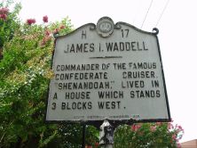
Commander of the famous Confederate cruiser, "Shenandoah," lived in a house which stands 3 blocks west.Plaque via North Carolina Highway Historical Marker Program, and is used with...
- ncmarkers
- north carolina
CHARLES MANLY

Governor, 1849-51. Whig Party leader. His law office, relocated & restored, stands 70 yds. N.Plaque via North Carolina Highway Historical Marker Program, and is used with their permission. Full...
- ncmarkers
- north carolina
TORY RAID

David Fanning and his Tories captured many Whig leaders here at old Chatham Courthouse, July, 1781.Plaque via North Carolina Highway Historical Marker Program, and is used with their...
- ncmarkers
- north carolina
GRANVILLE GRANT

Formed northern half of colony of North Carolina. Southern boundary was surveyed to a point just south of here in 1746.Plaque via North Carolina Highway Historical Marker Program, and is used with...
- ncmarkers
- north carolina