

HIDDENITE

A gem found only in N.C., named for W. E. Hidden, mineralogist of N.Y., who prospected in this area about 1880. Mines were nearby.Plaque via North Carolina Highway Historical Marker Program, and...
- ncmarkers
- north carolina
ORE KNOB MINE

Copper mine operated one mile north in the 1870s & 1880s. Site of Ore Knob, boom mining town, chartered 1875.Plaque via North Carolina Highway Historical Marker Program, and is used with...
- ncmarkers
- north carolina
JOHN STOKES

First U.S. Judge for District of N.C., 1790, captain in Revolution, state legislator, member of convention of 1789. His plantation was nearby.Plaque via North Carolina Highway Historical Marker...
- ncmarkers
- north carolina
PILOT MOUNTAIN

Landmark for Indians and pioneer settlers. Elevation 2,420 feet. State park since 1968. Stands 3 miles west.Plaque via North Carolina Highway Historical Marker Program, and is used with their...
- ncmarkers
- north carolina
VANCE HOUSE

Now historical museum, was temporary home of Gov. Zebulon B. Vance after Sherman's capture of Raleigh, April 1865. Is 350 yards southwest.Plaque via North Carolina Highway Historical...
- ncmarkers
- north carolina
JAMES HALL

Presbyterian minister, Revolutionary soldier and chaplain, educator, pioneer missionary in the Natchez country. Grave is 50 yards north.Plaque via North Carolina Highway Historical Marker Program,...
- ncmarkers
- north carolina
CLIO'S NURSERY

A school established about 1778 by the Rev. James Hall. Trained many prominent men. Closed about 1787. Was a few hundred yards E.Plaque via North Carolina Highway Historical Marker Program, and...
- ncmarkers
- north carolina
CENTRE CHURCH

Presbyterian, organized in 1765. Synod of the Carolinas formed there, 1788. Present building, erected 1854, is 1/2 mi. W.Plaque via North Carolina Highway Historical Marker Program, and is used...
- ncmarkers
- north carolina
GRANVILLE GRANT
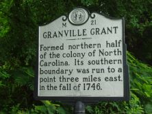
Formed northern half of the colony of North Carolina. Its southern boundary was run to a point three miles east, in the fall of 1746.Plaque via North Carolina Highway Historical Marker...
- ncmarkers
- north carolina
ASA GRAY

American botanist and Harvard professor. In July 1841, investigated the region's flora. Headquarters was in house that stood 50 yds. N.Plaque via North Carolina Highway Historical Marker Program,...
- ncmarkers
- north carolina
MONTFORT STOKES 1762-1842

Governor, 1830-1832; U.S. Senator; Federal Indian Commissioner. Home stood 1 mi. N.Plaque via North Carolina Highway Historical Marker Program, and is used with their permission. Full page here...
- ncmarkers
- north carolina
J. P. CALDWELL

Editor of Statesville "Landmark" (1880-92), Charlotte "Observer" (1892-1909). His home was two blocks north.Plaque via North Carolina Highway Historical Marker Program, and is used with...
- ncmarkers
- north carolina
MITCHELL COLLEGE

Founded 1856 as college for women. Presbyterian until 1959. Granted state community college status, 1973. Two blocks N.Plaque via North Carolina Highway Historical Marker Program, and is used with...
- ncmarkers
- north carolina
EBENEZER ACADEMY
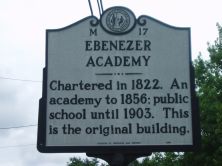
Chartered in 1822. An academy to 1856; public school until 1903. This is the original building.Plaque via North Carolina Highway Historical Marker Program, and is used with their permission. Full...
- ncmarkers
- north carolina
NORTH CAROLINA- VIRGINIA

NORTH CAROLINA / Colonized, 1585-87, by first English settlers in America; permanently settled c. 1650; first to vote readiness for independence, Apr. 12, 1776 b/w VIRGINIA / First...
- ncmarkers
- north carolina
NORTH CAROLINA- VIRGINIA

NORTH CAROLINA / Colonized, 1585-87, by first English settlers in America; permanently settled c. 1650; first to vote readiness for independence, Apr. 12, 1776 b/w VIRGINIA / First...
- ncmarkers
- north carolina
NORTH CAROLINA- VIRGINIA

NORTH CAROLINA / Colonized, 1585-87, by first English settlers in America; permanently settled c. 1650; first to vote readiness for independence, Apr. 12, 1776 b/w VIRGINIA / First...
- ncmarkers
- north carolina
JAMES B. GORDON

Brigadier general in the Confederate States Army. Mortally wounded near Richmond, Virginia, May 12, 1864. Birthplace stands 300 yards north.Plaque via North Carolina Highway Historical Marker...
- ncmarkers
- north carolina
RICHMOND PEARSON 1805-1878

Chief Justice of State Supreme Court, 1859-78. Conducted law school at Richmond Hill, his home, located 5 mi. NW.Plaque via North Carolina Highway Historical Marker Program, and is used with...
- ncmarkers
- north carolina
STONEMAN'S RAID

On a raid through western North Carolina Gen. Stoneman's U.S. cavalry occupied Statesville, April 13, 1865.Plaque via North Carolina Highway Historical Marker Program, and is used with...
- ncmarkers
- north carolina