
FIRST RURAL HEALTH DEPARTMENT

In 1912 Robeson County established first rural health department in U.S. three blocks N.Plaque via North Carolina Highway Historical Marker Program, and is used with their permission. Full page...
- ncmarkers
- north carolina
THE BARTRAMS

Naturalists John and William Bartram, in 1765 and later, used their kinsman's house, Ashwood, as operating base. Stood 2 mi. E.Plaque via North Carolina Highway Historical Marker Program, and...
- ncmarkers
- north carolina
WARREN WINSLOW 1810-1862
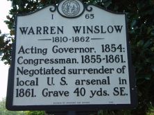
Acting Governor, 1854; Congressman, 1855-1861. Negotiated surrender of local U.S. arsenal in 1861. Grave 40 yds. SE.Plaque via North Carolina Highway Historical Marker Program, and is used with...
- ncmarkers
- north carolina
CONFEDERATE WOMEN'S HOME

Built in 1915 for the widows and daughters of state's Confederate veterans. Closed, 1981. Cemetery 300 yds. W.Plaque via North Carolina Highway Historical Marker Program, and is used with their...
- ncmarkers
- north carolina
C. M. STEDMAN 1841-1930

Last Confederate officer in Congress, 1911-1930; lawyer & lt.-governor. Grave is 2 blks. east.Plaque via North Carolina Highway Historical Marker Program, and is used with their permission. Full...
- ncmarkers
- north carolina
HENRY EVANS

Free black cobbler & minister. Built first Methodist church in Fayetteville. Died 1810. Buried 2 blocks north.Plaque via North Carolina Highway Historical Marker Program, and is used with their...
- ncmarkers
- north carolina
THE FAYETTEVILLE OBSERVER
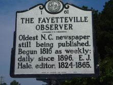
Oldest N.C. newspaper still being published. Begun 1816 as weekly; daily since 1896. E. J. Hale, editor, 1824-1865.Plaque via North Carolina Highway Historical Marker Program, and is used with...
- ncmarkers
- north carolina
FRANK P. GRAHAM 1886-1972

First president of Consolidated U.N.C., 1932-1949. U.S. senator; U.N. mediator, India & Pakistan. Birthplace was 50 yds. W.Plaque via North Carolina Highway Historical Marker Program, and is...
- ncmarkers
- north carolina
GABRIEL HOLMES 1769-1829
Governor, 1821-1824; Congressman. His son, Theophilus Holmes, a Confederate general. Home stood 2 mi. SE.Plaque via North Carolina Highway Historical Marker Program, and is used with...
- ncmarkers
- north carolina
DUNN'S CREEK QUAKER MEETING

Started about 1746; joined yearly meeting, 1760; discontinued about 1781. Site and cemetery are 2.5 miles S.E.Plaque via North Carolina Highway Historical Marker Program, and is used with...
- ncmarkers
- north carolina
BLACK RIVER CHURCH

Presbyterian. Organized 1740. Present building constructed 1859. First regular pastor was the Rev. Colin Lindsay.Plaque via North Carolina Highway Historical Marker Program, and is used with their...
- ncmarkers
- north carolina
STEWARTSVILLE CEMETERY

Begun 1785. Congressman James Stewart gave land. J. C. McLaurin, who founded Laurinburg, and many Scots buried here. Two miles southwest.Plaque via North Carolina Highway Historical Marker...
- ncmarkers
- north carolina
ST. ANDREWS PRESBYTERIAN COLLEGE

Chartered 1958; opened 1961. Formed by merger of colleges dating from 1858. Coeducational, four- year liberal arts college.Plaque via North Carolina Highway Historical Marker Program, and is used...
- ncmarkers
- north carolina
METHODIST UNIVERSITY

Chartered 1956 as four-year liberal arts college. Opened September 1960. University since 2006.Plaque via North Carolina Highway Historical Marker Program, and is used with their permission. Full...
- ncmarkers
- north carolina
CAMPBELTON

Colonial river port, incorporated in 1762. Later merged with Cross Creek to form the town of Fayetteville.Plaque via North Carolina Highway Historical Marker Program, and is used with...
- ncmarkers
- north carolina
PINELAND COLLEGE- EDWARDS MILITARY INSTITUTE

Founded 1875. Includes kindergarten through junior college. Campus is 250 yards west.Plaque via North Carolina Highway Historical Marker Program, and is used with their permission. Full page here...
- ncmarkers
- north carolina
REV. JAMES CAMPBELL

One of early Presbyterian ministers in N.C., 1757-1780. Organized Bluff, Barbecue, and Longstreet churches. Grave is 8 mi. east.Plaque via North Carolina Highway Historical Marker Program, and is...
- ncmarkers
- north carolina
RAFT SWAMP

After the Tory victory at McPhaul's Mill, the Whigs routed the Tories near here on Oct. 15, 1781, and broke their resistance in this area.Plaque via North Carolina Highway Historical Marker...
- ncmarkers
- north carolina
McPHAUL'S MILL
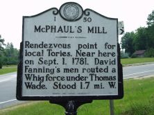
Rendezvous point for local Tories. Near here on Sept. 1, 1781, David Fanning's men routed a Whig force under Thomas Wade. Stood 1.7 mi. W.Plaque via North Carolina Highway Historical...
- ncmarkers
- north carolina
WILLIAM RUFUS KING

Congressman from N.C., 1811-16; Senator from Alabama for 29 years. Vice-President of the United States, 1853. Born six miles east.Plaque via North Carolina Highway Historical Marker Program, and...
- ncmarkers
- north carolina